


If you have any information on towns, schools, post offices, historical churches, founding fathers, location, history, etc., please submit the information to me for inclusion on this site.
Murray County OK Drugstores and Cafes
Early Post Offices of Chickasaw Nation
Populated Places in Murray County
*
Post Office **School & or Stores
* Dates = dates of service of
post office - **Dates = dates of service of school.
If other
names are listed at the end of the line, this is other name
community was also know as:
Arbuckle 1911 1922
Crusher/Big Canyon *
Big Canyon 1922 1961 Arbuckle *
Buckhorn
1-8-1908 to 6-30-1948 S24, T1S, R3E **
Buckhorn 1890 1910 none *
Carr Chapel 7-6-1908 to 7-16-1947 S28, T1N, R3E **
Carr Flat, 2
mi. S of Wynnewood. **
Chigley 1-11-1908 to 6-30-1959 to Joy S3,
1N, 2E **
Chigley 1900 1914 none *
Colbert 1-14-1908 to
5-13-1940 S12, T1S, R1E **
Crusher 1904 1911 Arbuckle *
Crusher-Arbuckle-Big Canyon 1-13-1908 to 9-20-1960 S20, T2S, R3E **
Davis 1-17-1908 to present Davis **
Davis 1890 Active none *
Denny - Community located between Hickory and Roff on Frisco RR.**
Dougherty 1-10-1908 to 1993? **
Dougherty 1887 Active Price *
Drake 1-15-1908 to 6-7-1950 S11, T2S, R3E **
Drake 1901 1920 none
*
Fairview 1-10-1908 to 7-7-1949 S2, T1S, R2E **
Fletcher
8-7-1908 to 5-28-1950 S8, T1S, R4E **
Gilsonite 1-15-1908 to
7-16-1947 S28, T1S, R3E **
Gilsonite 1900 1909 none *
Goose
Nest - zinc & lead mining community west of Davis**
Grandview -
platted community east of the Deaf School**
Harris ? to June 29,
1919 S4, T2S, R4E **
Hickory 1-25-1908 to 6-30-69**
Hickory
1893 1964 none *
Howard a.k.a. Jackson Separate s. of Hennepin
1-13-1908 to 6-30-1932 **
Iona 12-12-1907 to 7-6-1951 **
Iona
1894 1929 none *
Koller 9-29-1908 to 6-28-1947 S32, T1N, R4E **
Moss 6-1-1909 to 6-30-1947 S15, T1S, R3E **
Nebo 1-14-1908 to
7-1-1960 S23, T2S, R3E **
Nebo 1890 1922 none *
Oak Grove
1-15-1908 to 4-12-1967 **
Palmer 1-13-1908 to 7-7-1949**
Palmer 1892 1915 none *
Price's Chapel 2-7-1908 to 4-9-1931 S28,
T1S, R2E **
Prices Falls - 2 m. s. of Dougherty**
Red Oak
9-29-1908 to 6-30-1947 S6, T2N, R3E **
Rock Creek 7-13-1908 to
4-9-1931 S30, T1S, R2E **
Russell 1-13-1908 to 6-30-1932 S30,
T1S, R1E **
Scullin 12-12-1907 to 5-15-1931 **
Scullin 1901
1954 Vaughn *
Sorghum Flat - 2 m. n. of Dougherty**
Sulphur
12-7-1907 - Present **
Sulphur 1895 Active none *
Sunshine
9-29-1908 to 5-20-1932 S14, T1N, R2E **
Talley, 1S, 4E of
Wynnewood S36, T1N, R1E**
Valley View or Rocky Point or Guy
8-5-1908 to 7-7-1949 S19, T1N, R3E **
Vaughn 1896 1901 Scullin *
Washita - Wheeler or Wheeler Flats 3-13-1908 7-27-22 S18, T1N, R2E
**
Washita 1887 1900 none *
As the area of the Arbuckle Mountains was settled, several
things were vital to consider in determining where to live. First
was the proximity to the supplies one needed from Texas. All freight
had to be hauled by wagon from Gainesville or Denison. The railroads
did not come to Murray county until 1887 although the Katy RR was
ran through eastern Oklahoma more than 10 years earlier. Also, the
crops produced by the farmers had to be sold in Texas.
Another
consideration was that the Comanche and Kiowa were still making
frequent raids into the Chickasaw Nation. These raids always ended
with all the victims being killed and all goods taken by the
raiders. This is the reason that Ft. Arbuckle was closed in the
Arbuckle Mountains and moved to it's current location at Ft. Sill.
The Cavalry had to move closer to the Comanche home territory.
Safety from raids was always on the settlers minds, both Indian and
white. The mountains provided a natural barrier.
Most important
to the settler of the time was a fresh water supply year round. This
is why most of the early settlement was along streams. Larger
streams such as the Washita River were used as pathways. Larger
streams were also used to power grist and saw mills as well as water
powered cotton gins.
Another reason for the importance of the
stream identification is that before statehood, many of the physical
references to land were made by using streams and rivers as
boundaries. Or, people simply said they lived on Squirrel Creek.
This will help locate the area a little closer.
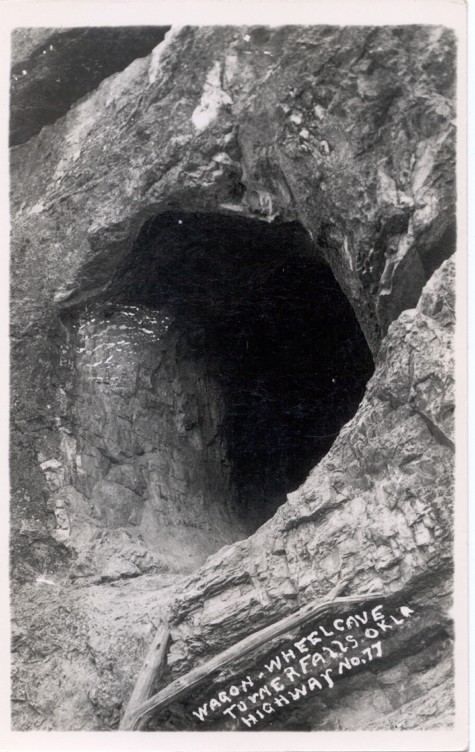
Here is a list of the names and coordinates of the larger
caves in Murray County. I found this information in an old copy of
the Oklahoma Geological Society magazine from the 1950's and is
presented as information only. Please note the following:
1. I
know nothing about the caves.
2. I do not know who owns the land
on which they are located.
3. I do not know how to contact them.
4. Most people will not let you on their property to explore the
caves because of liability associated with the dangerous sport of
spelunking.
NOTICE: DUE TO THE INCREASE IN VANDALISM AND
TRESPASSING ON PRIVATE PROPERTY, THE LOCATIONS OF THE CAVES HAVE
BEEN DELETED TO PRESERVE THE GEOLOGICAL AND BIOLOGICAL FEATURES OF
THE CAVES. THE LOCATIONS OF THE CAVES WILL NOT BE POSTED AND I WILL
NOT ANSWER EMAILS ABOUT THE LOCATIONS OF THE CAVES.
BITTER ENDERS CAVE
CORKSCREW CAVE
LITTLE CRYSTAL CAVE
(ARROW CAVE)
MYSTIC CAVE
STRIBLING CAVE
WAGON WHEEL CAVE
WHITE WOMAN CAVE
WILD WOMAN CAVE
WOMAC CAVE
Submitted by Dennis Muncrief, June 2009.
If you have questions, contributions, or problems with this site, email:
Coordinator - Rebecca Maloney
State Coordinator: Linda Simpson
Asst. State Coordinator: Mel Owings
If you have questions or problems with this site, email the County Coordinator. Please to not ask for specfic research on your family. I am unable to do your personal research. I do not live in Oklahoma and do not have access to additional records.

