

If you have any information on towns, schools, post offices, historical churches, founding fathers, location, history, etc., please submit the information to me for inclusion on this site.
Business Directory for Paul's Valley 1893
Business Directory for Paul's Valley 1909
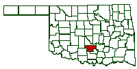 Where
Garvin Oklahoma is
Where
Garvin Oklahoma is
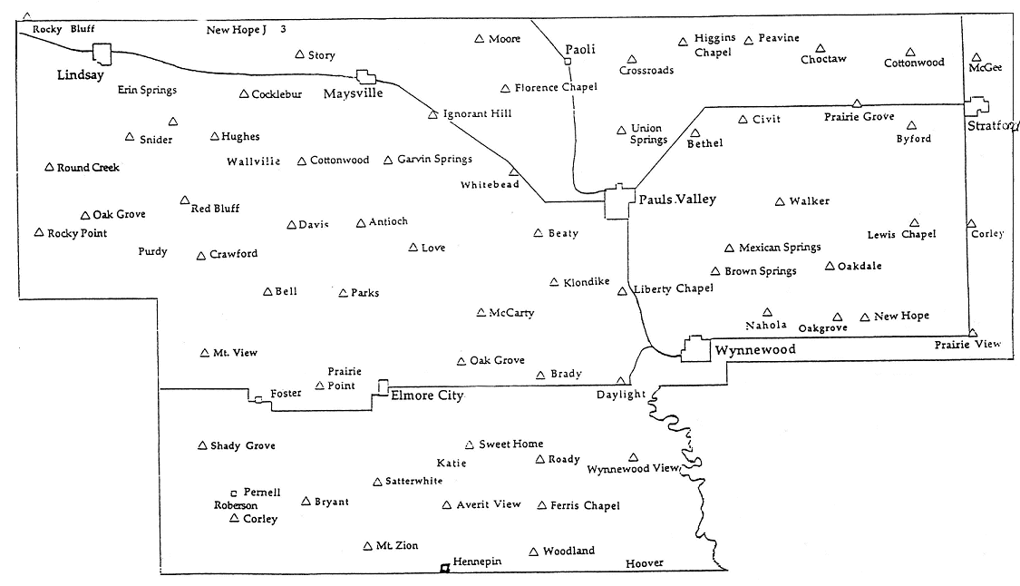
List of
Populated Places of Garvin County, Oklahoma from the
U.S. Geological Survey
| Feature Name | Lat/Long | USGS 7.5' x 7.5' Map |
|---|---|---|
| Antioch | 344330N/0972419W | Elmore City North |
| Beaty | S.W of Pauls Valley | |
| Brady | 343722N/0971656W | Hennepin |
| Bug Scuffle | West of White Bead | |
| Civit | 344721N/0970731W | Pauls Valley East |
| Elmore City | 343722N/0972346W | Elmore City South |
| Erin Springs | 344839N/0973623W | Lindsay |
| Florence Chapel | West of Paoli | |
| Foster | 343659N/0972920W | Elmore City South |
| Gulf Junction | 344344N/0971211W | Pauls Valley |
| Hennepin | 343032N/0972048W | Hennepin |
| Hughes | S.W. of Maysville | |
| Katie | 343446N/0972107W | Hennepin |
| Lindsay | 345005N/0973608W | Lindsay |
| Maysville | 344902N/0972420W | Maysville |
| McCarty | West of Pauls Valley | |
| McGee | 344932N/0965725W | Stratford |
| Neill | 344918N/0973044W | Lindsay |
| Paoli | 344936N/0971532W | Paoli |
| Pauls Valley | 344424N/0971319W | Pauls Valley |
| Pernell | 343341N/0973035W | Pernell |
| Prairie View | East of Wynnewood | |
| Purdy | 344257N/0973514W | Lindsay South |
| Satterwhite | 343353N/0972417W | Elmore City South |
| Story | 345119N/0972730W | Maysville |
| Stratford | 344748N/0965733W | Stratford |
| Walker | East of Pauls Valley | |
| Wallville | 344605N/0973013W | Lindsay |
| White Bead | 344548N/0971806W | NW Pauls Valley |
| Woodland | East of Hennepin | |
| Wynnewood | 343836N/0970951W | Wynnewood |
| Feature Name | Lat/Long | USGS 7.5' x 7.5' Map |
|---|---|---|
| Bethel Church | 344653N/0970952W | Byars SW |
| Cottrells Mission | 344313N/0970113W | Pauls Valley NE |
| Dixon Chapel | 345027N/0970326W | Byars |
| Fair Oak Church | 343908N/0972106W | Elmore City NE |
| Free Holiness Church | 344933N/0971245W | Byars SW |
| Home Sweet Home Church | 343504N/0972000W | Hennepin |
| Little Flock Church | 343358N/0972723W | Elmore City South |
| Love Church | 344241N/0972214W | Elmore City NE |
| Midway Church | 343036N/0973035W | Pernell |
| Mount Zion Church | 343137N/0972419W | Elmore City South |
| Mount Zion Church | 344106N/0970525W | Pauls Valley NE |
| Mountain View Church | 343813N/0973207W | Purdy |
| Prairie View Mission | 343903N/0965807W | Hart |
| Roady Church | 343447N/0971622W | Hennepin |
| Saint Timothy Church | 344305N/0971315W | Pauls Valley |
| Salem Church | 343117N/0972109W | Hennepin |
| Sandy Hill Church | 344424N/0970011W | Pauls Valley NE |
| Shady Grove Church | 343537N/0973057W | Pernell |
| Southside Church | 344315N/0971247W | Pauls Valley |
| Valley View Church | 344558N/0971130W | Byars SW |
| Walker Church | 344417N/0970602W | Pauls Valley NE |
City and
Township
Personal
Property Assessments
Taken from Garvin County Newspapers
|
This material is donated by people who want to communicate with and help others. Every effort is made to give credit and protect all copyrights. Presentation here does not extend any permissions to the public. This material can not be included in any compilation, publication, collection, or other reproduction for profit without permission. |
Walker Township-Personal Property Assessments-May 20, 1920
What the Heck is a Township?
First of all, a township has nothing to do with a "town". Already confused aren't you. There are two types of Townships. One is a Congressional township. The other is a political township.
A Congressional Twp. is a unit of measure for land. With the addition of the Western frontier of Ohio, Oklahoma etc, Congress wanted to survey the new land to find out how much there was and to create some uniform standard for land survey and ownership. This was to replace the old "meets and bounds" system which ran from some creek to some tree and then north to some other tree. Problem is that creeks move around and trees die. Congress decided to create the Township. Each township was composed of 36 sections of land measuring 1 mile square. Hence a Congressional township was a unit of land that was 6 miles by 6 miles.
A political township is one of no standard size. The Turner township in Murray county is 99 square miles in size. Mosley township is exactly 6 miles by 6 miles and is exactly 36 square miles in size. A political township was began as a way to build and maintain Schools, Roads, Justice of the Peace, Constable, etc that have meaning in every day life. Because the counties were not exactly square in shape, there are parts of another Congressional township attached to a Political Township.
The sections, or one mile squares of land, are numbered in an odd way as can be seen on the diagram below. With North being the top of the diagram, the sections are numbered from right to left and then the number wrap back and forth. Each 1 mile section contains 640 acres.
Townships are measured from two lines that cross at right angles. The line that runs east and west is called the Baseline. The line that runs north and south is called the Meridian. All of Oklahoma, except the Panhandle, is surveyed from a point 1 mile south of Ft. Arbuckle on the Murray - Garvin county line. The north-south line is called the Indian Meridian. The baseline 'generally' runs along the course of Highway 7 across Murray County.
Each Twp. is measured as north or south of the baseline, such as Township 1 North. This means that the Twp is the first six mile by six mile square of land north of the baseline. So this Twp would be from 0 miles to 6 miles north of the baseline.
Now the east - west dimension is called a Range. Now, if a township is east of the meridian or north/south line, it has an East designation. The Twp. west of the Indian Meridian, it has a West designation. So, a township that has a designation of Range 1 East would be the first 6 mile by 6 mile east of the Indian Meridian.
To progress further into this, a township with the designation of Twp 2 North, Range 2 East, would mean that the area we want is about 12 miles east of Ft. Arbuckle and about 12 miles north of the base line.
Diagram of a Township
| 6 | 5 | 4 | 3 | 2 | 1 |
| 7 | 8 | 9 | 10 | 11 | 12 |
| 18 | 17 | 16 | 15 | 14 | 13 |
| 19 | 20 | 21 | 22 | 23 | 24 |
| 30 | 29 | 28 | 27 | 26 | 25 |
| 31 | 32 | 33 | 34 | 35 | 36 |
Now, we come to the legal description of a piece of land. This is very easy to understand. We have the Range and Township down by now. All we have to do is add the section of land to the description. Let's assume that we have a description like: S 31, T 1 N, R 1 E. Looking above at the Diagram to section 31. This area would be the section where the Indian Meridian and the Baseline cross on the west boundary and the south boundary. So, the southwest corner of the section 31 would be the Initial Point (IP) or the beginning point of the survey.
Intersection of the baseline and Meridian
The Green Township is T 1 N, R 1 E.
| Twp 1 N, R 1 W | 6 | 5 | 4 | 3 | 2 | 1 |
| 7 | 8 | 9 | 10 | 11 | 12 | |
| 18 | 17 | 16 | 15 | 14 | 13 | |
| 19 | 20 | 21 | 22 | 23 | 24 | |
| 30 | 29 | 28 | 27 | 26 | 25 | |
| 31 | 32 | 33 | 34 | 35 | 36 | |
| Twp 1 S, R 1 W | Twp 1 S, R 1 E | |||||
We now know that a township is measured north or south of the baseline and east or west of the meridian. We know that each township contains thirty six sections that measure one mile square. Each section contains 640 acres. Therefore a half section is 320 acres and a quarter section contains 160 acres. Lets look at Section 31 in the diagram below.
Section 31
| NW 1/4 160 acres | NE 1/4 160 acres |
| SW 1/4 160 acres | SE 1/4 160 acres |
If we owned the 160 acre piece of land that was at the convergence of the baseline and the meridian, the legal description would be the Southwest 1/4, Section 31, Township 1 North, Range 1 East or in shorthand, SW1/4 S 31, T 1 N, R 1 E.
Now you know what a Township is, why they were created and how they work.
|
This material is donated by people who want to communicate with and help others. Every effort is made to give credit and protect all copyrights. Presentation here does not extend any permissions to the public. This material can not be included in any compilation, publication, collection, or other reproduction for profit without permission. |
Not sure what time period this is as I can name at least one community, Homer, which it does not show. Homer was down around Hennepin & Hoover and may have been over into Murray County
If you have questions, contributions, or problems with this site, email:
Coordinator - Rebecca Maloney
State Coordinator: Linda Simpson
Asst. State Coordinator: Mel Owings
If you have questions or problems with this site, email the County Coordinator. Please to not ask for specfic research on your family. I am unable to do your personal research. I do not live in Oklahoma and do not have access to additional records.