

Mayes County History
The area that became Mayes County is rich in history, containing the location of the first white settlement in what is now called Oklahoma. In 1796, Major Jean Pierre Chouteau, an Osage Indian trader and agent, established a trading post at the junction of the Grand/Neosho River and Saline Creek, at what is today called Salina. Flat boats plied their trade along the river and as early as 1817 keel boats from Ft. Smith (Arkansas) were known to travel up the river to the Chouteau Trading Post. The trading post flourished through the Osage occupation of the area, which ended with the formation of Indian Territory and this area was assigned to the Cherokee Nation. Christian missions were established here as early as 1820/1823.
But even before 1890 the nonIndian population, both legal and illegal, had grown to over 70 percent of the total population of Indian Territory. The first U.S. census of Indian Territory in 1900 shows a further influx of nonIndians had occurred between 1890 and 1900; most of the nonIndians being former residents of the adjacent states of Arkansas, Missouri, Texas and Kansas. Prior to the land allotment, the lands of the Five Civilized Tribes had been held in tribal ownership. No individual Indian owned any land, but were free to use as much as they needed if it did not infringe upon their neighbor's needs. However, they did own their improvements; the home, barn, the planted crops, cleared fields and such. While these improvements could be traded or sold, tribal law restricted the transaction to another citizen of the same tribe.
The land was distributed by allotment to citizens of these Nations on the basis of their enrollment on the 1902/1906 Dawes Roll. The average land allotment to each Cherokee "citizen by blood" was 110 acres of average grade land. Freedman (the former slaves of the Cherokees) were allotted 40 acres each of the Nation's land. But since the Indians had no concept of land ownership, in just a few short years most of the land was in the hands of non-Indians.
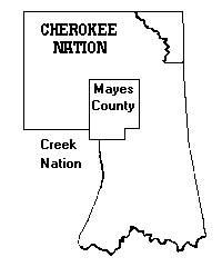
Mayes County was formed at statehood (1907) from parts of the Cherokee Nation, plus a small area of the Creek Nation of Indian Territory and was named in honor of Samuel Houston Mayes, who served his people and the Cherokee Nation as Principal Chief from 1895 to 1899.
 |
 |
Little more on the History of Mayes County
In the beginning.... Indians called the locale around Pryor "Coo-Y-Yah" meaning place of the huckleberries. In commemoration, today, a street bears the name. Nathaniel Pryor, great grandnephew of Pocahontas, and a scout with the Lewis and Clark Expedition, married an Osage Indian and set up a trading post near what is now the City of Pryor, Oklahoma.
Nathaniel Pryor's gravesite had been on private property five miles southeast of Pryor for many years but in 1982 the Mayes County Historical Society moved the grave to the Fairview Cemetery, east of Pryor.
The first United States Post Office opened in the Archer & Bryan Store, on the Texas Trail, July 15,1870. This was known as Pryor's Creek, with the possessive connotation. On November 27, 1878 a new post office by the name of Pryor Creek (the 'S had been dropped) was opened.
The MK&T (now Union Pacific) Railroad determined the final location of the City of Pryor Creek when it opened the depot in what was then Coo-Y-Yah. The post office officially dropped the word "Creek" from the name on January 26,1909 although all other legal records retain the word.
The first school was a subscription school organized in 1887 in a one-room building. By 1894 the school had enlarged to rooms, and in 1896, a large, two story, eight-room building was erected.
On June 28,1898, by Act of Congress, towns were given permission to incorporate under the laws of Arkansas, and to create public school systems. The first free public school system in the city opened October 2, 1902. An additional building was erected in 1915 which was used for the high school and the 1908 building was designated a grade school.
Oklahoma became the forty-sixth in the union a state in 1907, and boundaries were set that included Pryor Creek and the surrounding area. Today, the Arkansas border is roughly 39 miles from the community. Oklahoma itself is named from two words in the Choctaw Indian language - "Okla" meaning people and "humma" meaning red, literally meaning red people. There are descendants of sixty-seven tribes living in the state.
The flags of Spain, France, Napoleon, Mexico, Texas, Confederate States and Great Britain flew over the area until replaced by the flag of the United States of America.
Pryor Creek was incorporated as a city under the laws of the State of Oklahoma. A city charter was adopted at a citywide vote on January 16, 1951. Governor Johnson Murray signed the charter for the State of Oklahoma on January 30, 1951.
In 1963 the voters of the community decided not to drop the word "Creek" from the city's name, as the feeling was one of historical significance. Therefore "Pryor Creek" remains the official name, although most residents and visitors know the community simply as Pryor.
This region has a rich cultural history. Until the 1830's this area was part of the hunting ground of the Osage Indian tribe. In 1796, Major Jean Pierre Chouteau opened a trading post near present day Salina, on the shores of Lake Hudson. The trading post encouraged fur trapping along the Grand River and its tributaries. This site significantly became the oldest white settlement in the state, and the Chouteau Museum commemorates this colorful history.
Near the town of Chouteau is Mazi which is near where the Union Mission was established in 1820. It was at this mission that the first school in the state was organized in 1821, the first printing press was located, and the first book published in Oklahoma was printed in 1835.
Today the population of Mayes County is very diversified. Many descendants of those original Indian land owners still reside here, and are very proud of their Indian ancestry.
Mayes County History Links
Mayes County | The Encyclopedia of Oklahoma History and Culture
Mayes County, Oklahoma - Wikipedia
Genealogy Trails - Mayes County, OK History
Mayes County Site Search
Mayes County Site Directory
| In Memoriam of Pryor School Boys |
| County Pioneers |
| Nice Places of the County |
| Whitaker Children's Home |
General Information
Links to web sites that are not part of the USGenWeb Project are provided for your convenience and do not imply any endorsement of the web sites or their contents by The USGenWeb Project.
NOTICE: In keeping with our policy of providing free Information on the Internet, data may be used by non-commercial entities, as long as this message remains on all copied material. These electronic pages may NOT be reproduced in any format for profit or for presentation by other persons or organizations. Files may be printed or copied for Personal use only. Persons or organizations desiring to use this material for purposes other than stated above must obtain the written consent of the file contributor.