
Maps
'n' More
Created
By
Sharon McAllister

|
|
Maps
'n' More |
|
|
|
||
|
|
|
||
|
|
|
|
|
|
|
|
|
|
|
|
|
|
|
|
|
|||
| Back to Hughes County Township Maps | Back to Hughes County Cemetery Lists |
Hughes - T9N-R10E
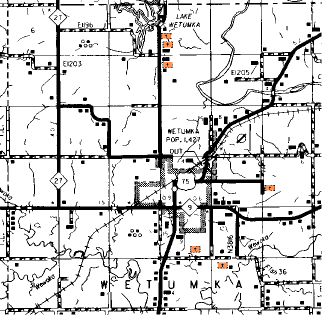
The topographic map shows the northernmost cemetery in Section 3 as the Salt Creek Church and the other one as unnamed. The one in Section 10 is also unnamed. The cemetery in Section 24 is the Wetumka Cemetery, the one in Section 27 is unnamed but near the Wetumka Church. The one in Section 35 is Barnett.
| Cemetery | Sec | Latitude | Longitude | Quad | |||
| Barnett Cemetery | OK | Hughes | cemetery | 35 | 351258N | 0961323W | Wetumka |
| Indian Baptist Church | This cemetery is located from the intersection of Hwy 9 and Hwy 75, one mile south to the Wetumka Indian Baptist Church sign on the east side of the road. Turn east and go .6 of a mile and the church is on the north side of the road with the cemetery next to the church on the west side of the churchyard. | 27 | |||||
| Salt Creek Cemetery | OK | Hughes | cemetery | 3 | 351652N | 0961440W | Weleetka |
| South Community | The cemetery is located 1 mile south of Wetumka on highway 75, turn east (left) on E/W 124 and follow it to the end, about 1 and ¼ miles. The cemetery is on the south side of the road. [Location matches that of Barnett on the map.] | ||||||
| Wetumka Cemetery | OK | Hughes | cemetery | 24 | 351414N | 0961231W | Wetumka |
Click on cemetery name for more details from GNIS. Use Lat/Long and Quad name for consulting conventional maps or searching Topozone.
![]()
|
Page last updated
on
Tuesday, July 21, 2026
This site maintained by
Mel Owings
![]()