
Maps
'n' More
Created
By
Sharon McAllister

|
|
Maps
'n' More |
|
|
|
||
|
|
|
||
|
|
|
|
|
|
|
|
|
|
|
|
|
|
|
|
|
|||
| Back to Hughes County Township Maps | Back to Hughes County Cemetery Lists |
Hughes - T8N-R9E
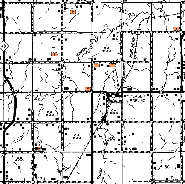
The topographic map shows the cemeteries in Sections 8, 15 and 16 but does not give their names. The one in Section 4 is not shown, but appears to be near the Salt Creek Church.
The one in the SW corner of Section 29 is shown as McCaybe.
| Cemetery | Sec | Latitude | Longitude | Quad | |
| Fairview Cemetery | Follow the paved road to Yeager and on through town. From Yeager head start, go north and stay on the paved road as it turns to the east. Go east for 2 miles, north 2 miles to where the pavement curves again to the east. Leave the pavement and go north for about 50 yards. The cemetery is on the corner but there is no sign and it is a little had to see. | 1 | |||
| McCaybe Cemetery | 29 | 350749N | 0962318W | Wewoka East | |
| Salt Creek Cemetery | 4 | 351652N | 0961440W | Weleetka | |
| Yeager | From State Highway 48, Broadway Of America, and US 270 intersection, 3 miles east on 270 to the Yeager Road, turn north and go 5 miles on a blacktop road. Continue on north when the blacktop turns east for about 100 ft. (This is N/S 374 and E/W 128). Turn west and go to the top of the hill, about .01 of a mile and the cemetery sets on the north side of the road. | 15 |
Click on cemetery name for more details from GNIS. Use Lat/Long and Quad name for consulting conventional maps or searching Topozone.
![]()
|
Page last updated
on
Tuesday, July 21, 2026
This site maintained by
Mel Owings
![]()