|
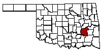
Pittsburg County |
|
 |
 |
 |
 |
 |
 |
04 Land Records & Maps
Training Tool
1
2
3
4
5
6
7
Process/Presentation
Presentation
National Archives Links to cartography, gazetteers, and maps.
USGS Topview
Podcast/Training Courses
Plat Map - 2008
How to Overlay Plat Maps on Google Earth - 2013
An Introduction to TopoView 2015
Gazetteer
Getty Thesaurus of Geographic Names® Online
Overlays of historical maps on current maps to find today's location in historical context
NYPL Map Warper
Pittsburg - none
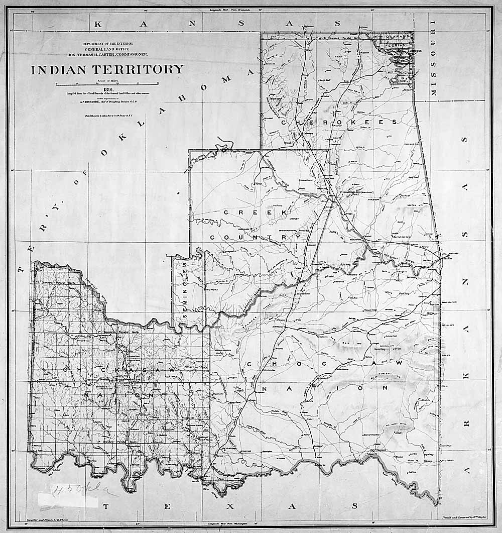
Oklahoma
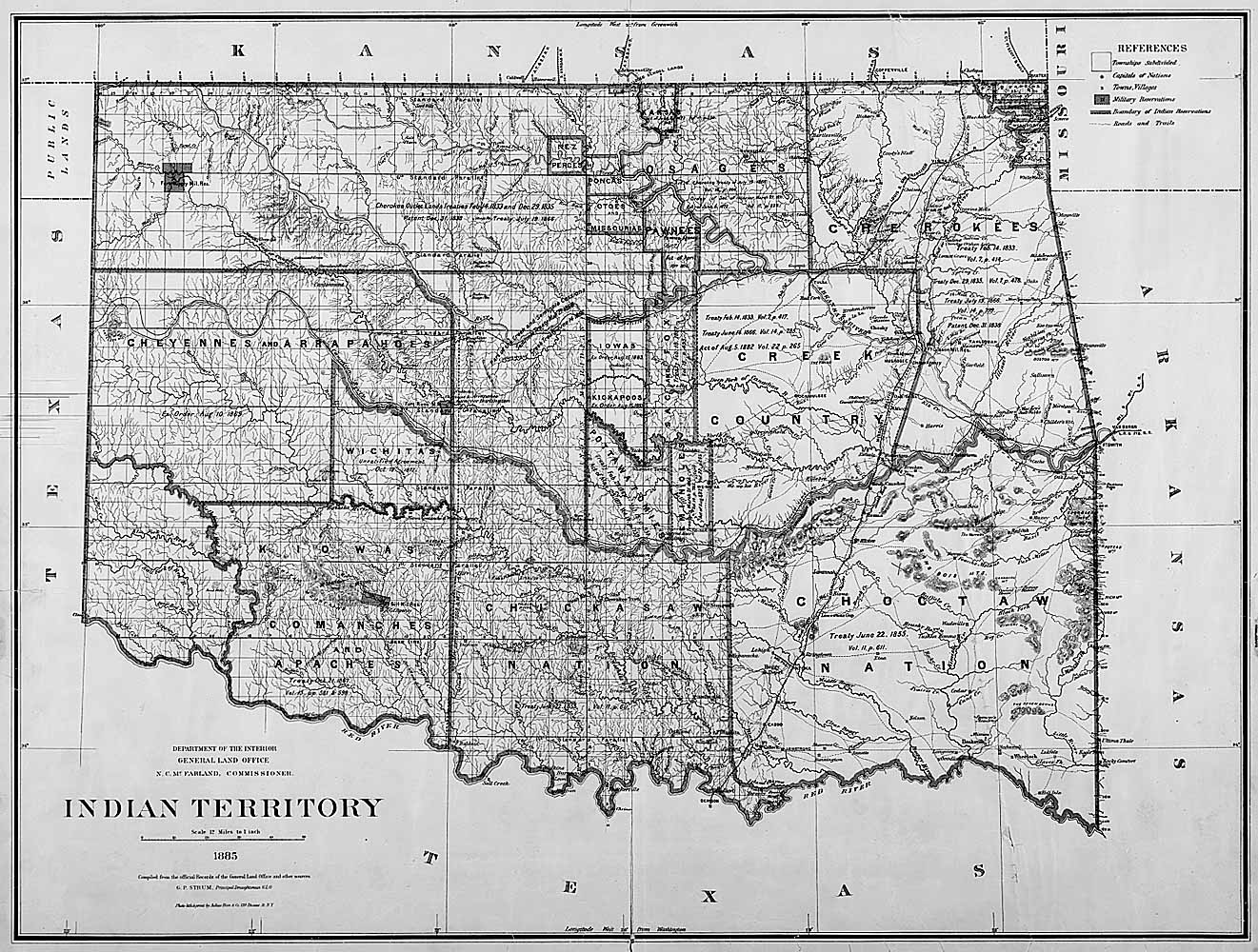
Indian Territory
Wiki/URL
Cyndi's List
Plat Map
Lot and block survey system
About Land Records
BlogsHandouts
Using Maps in Genealogy
General Land Office Primer
US Military Bounty Land Warrants
Land Records Research Guide
American Indian Land Research Guide
Public Lands - how to plot property on Orginal township/range survey from BLM
10 Cool Things You Can Learn from Deeds
Locating Land Records on the BLM's General Land Office Records Website
Historic Land Ownership Maps and Atlases Online
Digging for Deeds
Land Records Online
Books
Lloyd Bockstruck’s, Revolutionary War Bounty Land Grants Awarded by State Governments
Family Tree Magazine
Land Records January 2014 page 33
Maps
USGS
Mapping the U.S., Block by Block
The Sanborn Fire Insurance Map
Maps
Oklahoma
search on left for:
Pittsburg County
Pittsburg County Township Maps
OHS
Library of Congress
MapWorks - some are free
10,000 Maps in the Oklahoma Historical Society
David Rumsey Map Collection
Maps of United States Indians by State
Allotment Maps
Perryville
1850
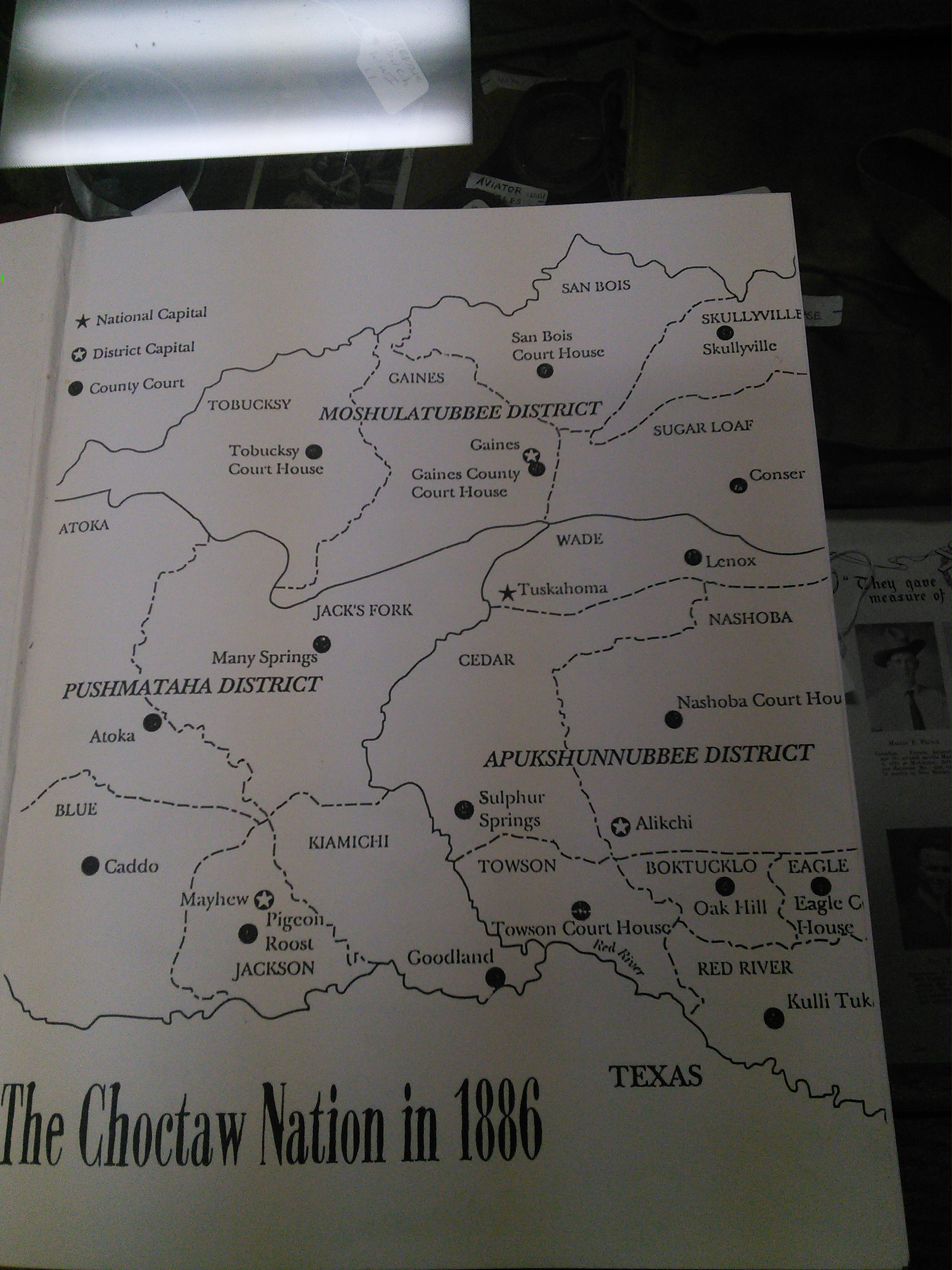
Pittsburg County
From Life and Times of the Choctaw Orginal Enrollees
Sanborn Fire Insurance Map Pittsburg County, Oklahoma.
1950 Census ED map
#2 Mcalester specific list wards
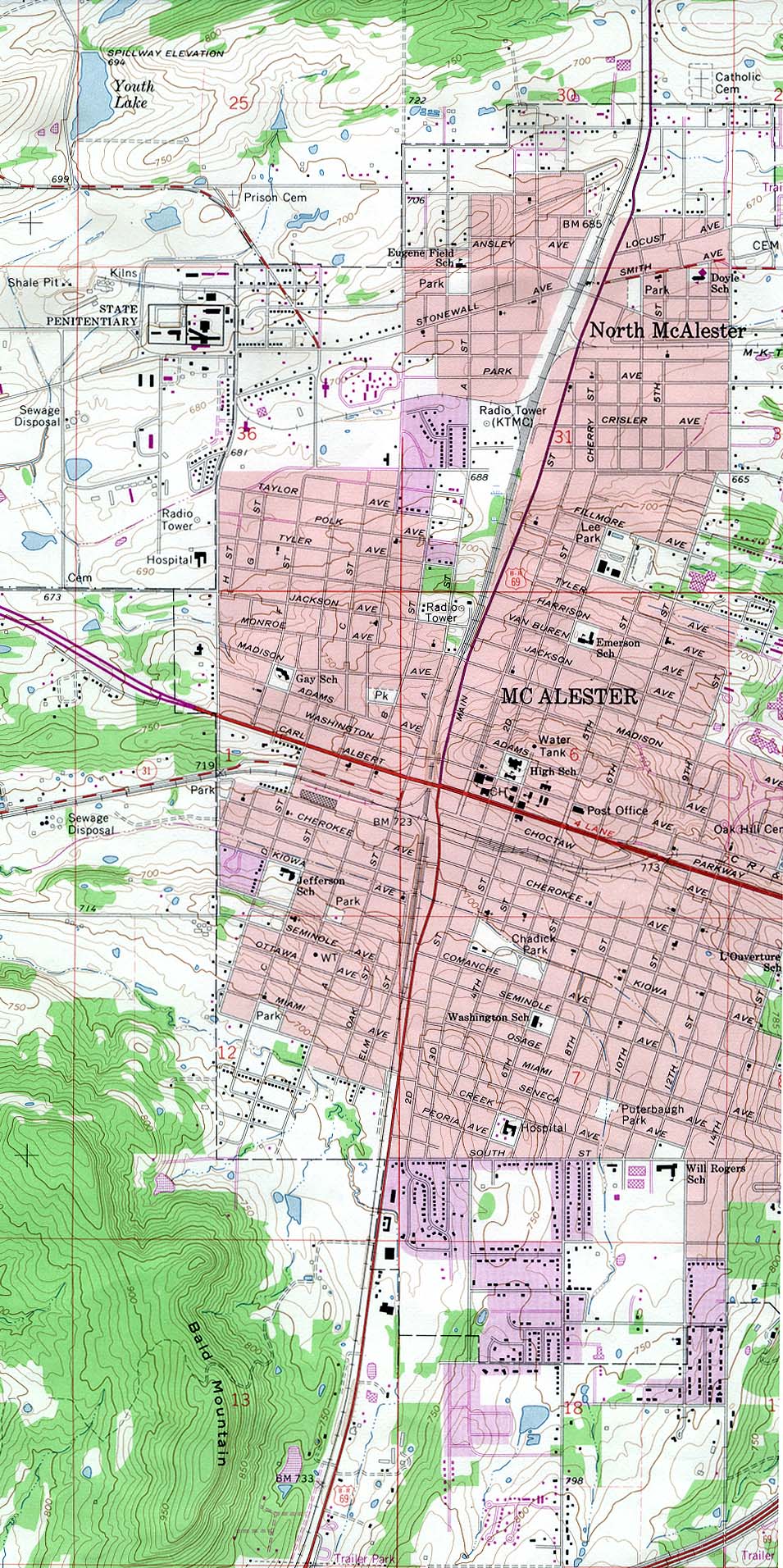
1978 McAlester UT
Oklahoma: Individual County Chronologies
See Indian Territory
See Pittsburg
2015 Map
Pittsburg
Jefferson Highway
Jefferson Highway
Oklahoma/ Oklahoma Territory/Indian Territory
Gregg,
Josiah, 1806-1850
Indian Territory, Northern T …
1844
Exploration Book
Mitchell,
Samuel Augustus
A New Map of Texas Oregon an …
1846
Pocket Map
1856-66 Oklahoma Map
Book - Oklahoma - A history of the Sooner State by Edwin C. McReynolds
54-10052
p214 Great map
Room 1 PCGHS Library
Books - Oklahoma - Its Origins and Development by Victor E. Harlow 1949
p 176 Map Indian Country during the civil war - Good for Battles
PCGHS Library - 5th edition Room 1
Old
Territory of Louisiana 1805 - 1812
Wikipedia
Missouri Territory Before Indian Territory 1812
Wikipedia
1819 Territory of Arkansas Before Indian Territory
Wikipedia
Civil war map with Native american key locations page 27
1857
Indian Territory 1834 - 1907
Wikipedia
Oklahoma: Consolidated Chronology of State and County Boundaries
1875
1881 Indian Territopry
1885 1891
1885
1887
1889
1891
1892
1894
1898
#2 1898
1902
#2 1902
#3 1902
#4 1902 with townships
1903
#2 1903 Railroads
1904
1906
1909
1913 Highway road map
1913 Nat Archives
1914
1919
1919 2
1920
1920 2
1920 3
1920 4
1922
Oklahoma Department of Transportation Map Archive 1866-1953
Oklahoma 2014-2015 State Railroad Map
Tribal Jurisdictions in Oklahoma 2015
Oklahoma Petroleum Information Center
Coal Mines 1979 takes time to down load - can be expanded
The Oklahoma State Archives
Not on-line
Oklahoma Maps UT
Newberry Library Map collection - Oklahoma -
OSU Digital Serial Set back to 1703
My Genealogy Hound
Historic Oklahoma County and indian Territory Maps 1905 Choctaw Nation (good for Eufaula in Creek)
Oklahoma 2015 maps
Changing US (county) Boundries
Newberry Atlas of Historical County Boundries
Map of the 13 Original States
also includes Orginal english Grants 1606-1732
Free Sanborn Fire Insurance Maps
Library of Congress Sanborn Maps
Sanborn Fire Insurance Maps - Texas
Census scope
Pownall,
Thomas, 1722-1805; …
Map of the Middle British Co …
1776
[Exploration Book, Geography
Native American
2014 National Archives Virtual Genealogy Fair Day 2- Overview of American Indian Records and Resources on Archives.gov
Agenda
YouTube
State of Sequoyah
Sequoya
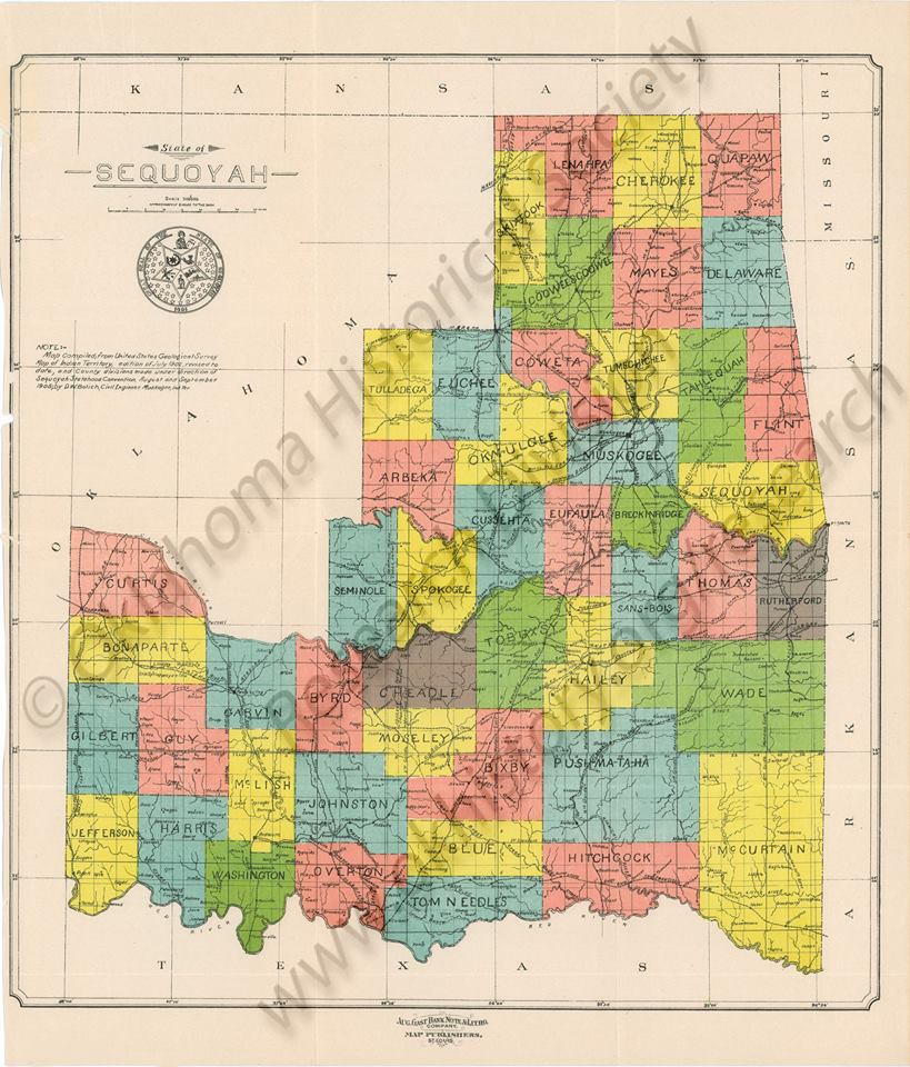
1850 Choctaw Nation
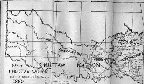
Source
CHOCTAW AND CHICKASAW NATIONS
Trail of Tears
Trail of Tears 2
1900 Cherokee Country
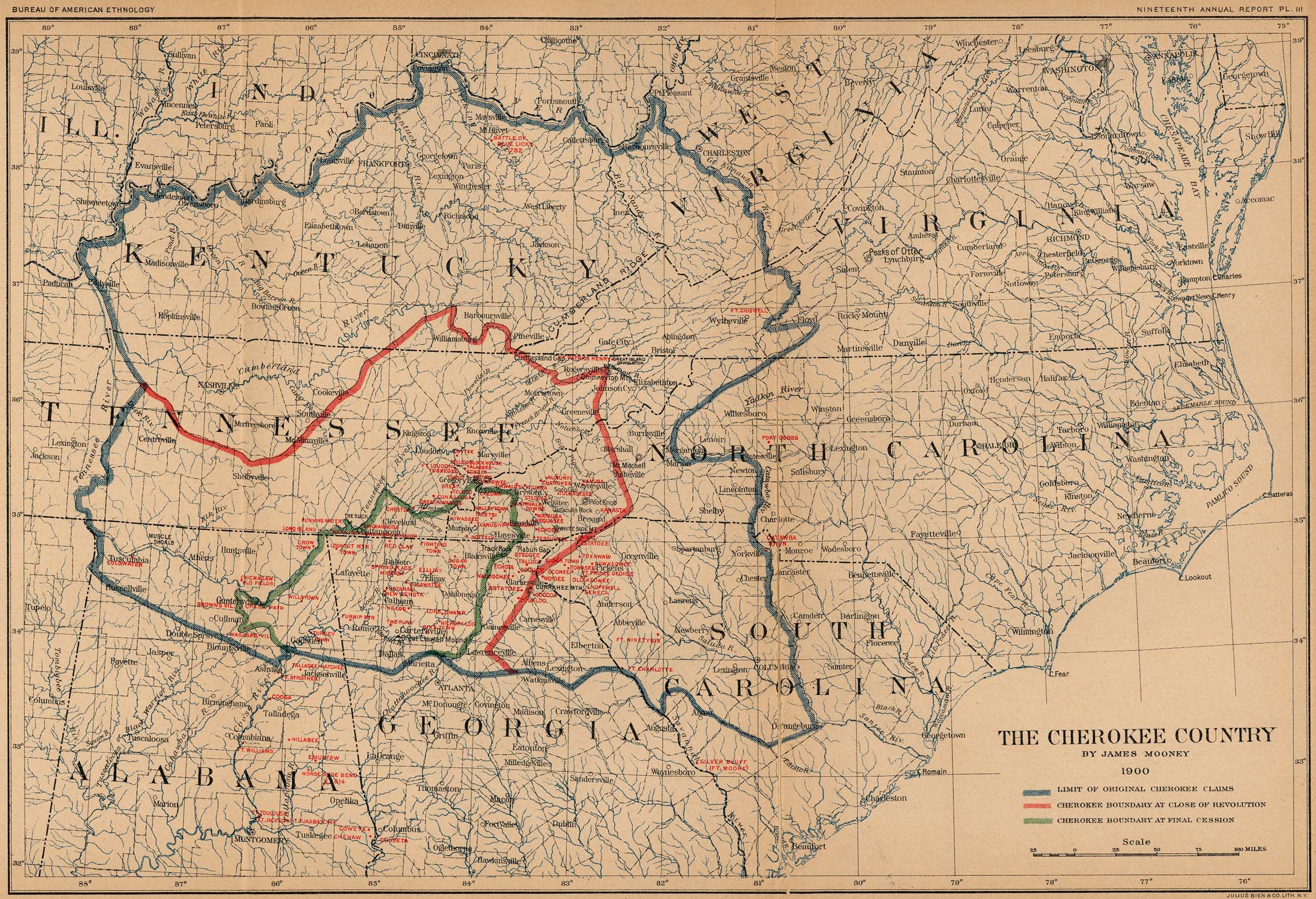
Tribes
Interactive Time-Lapse Map
Early Indian Tribes, Culture Areas,
Indian Terr
Native Indian Tribes
1836
1776
Teaching
With Documents:
Maps of Indian Territory, the Dawes Act, and Will Rogers' Enrollment Case
File
Records of the Bureau of Indian Affairs search on Maps
Black Americans
Slave Trade
How Slavery Expanded
Last Update: 10-Oct-2019 6:40 AM | |
OKGenWeb/ITGenWeb is part of the USGenWeb Project. Links to web sites that are not part of USGenWeb Project are provided for your convenience and do not imply any endorsement of the websites or their contents by The USGenWeb Project. | |
WebMaster Robert O. Pulse: rop720@aol.com | |
State Coordinator: Linda Simpson Asst. State Coordinator: Mel Owings |