|
Delaware County
&
Oklahoma Maps
OKGenWeb has one of the very best map collections. Here you will
find links to maps of Delaware County, Oklahoma State and Indian Territory.
Why Use A County Outline Map?
Many government records of genealogical value in the United States are kept by
county governments, knowing which county an ancestor lived in, and which counties are nearby, is
an important part of U.S. genealogical research.
Among the county records of importance are:
Marriage Records
These may be actual records, licenses, or bonds, with the names of the bride
and groom, the date of the marriage (or license or bond), and often the names of the
parents, minister (or Justice of the Peace), and witnesses.
Probate Records
Wills and other papers relating to the deceased. These will usually show
the names of family members and give their relationships to the departed.
Land and Property Records
Deeds and other records of the transfer or lease of property, with the
names of the seller and buyer, a description of the property, the price of the
transaction, and the date.
Court Records
These can range from civil to criminal cases, as well as county business, granting
business licenses, and other activities.
Census Schedules
Although not compiled by county governments, the federal censuses (taken
every ten years beginning in 1790) were organized by counties. Beginning in 1850, federal
censuses showed every member of the family with his or her age and birthplace.
1895
Atlas - This is indexed for Indian Territory and Oklahoma Territory. If you
know the county boundaries of today and not sure of the Territorial boundaries this is the place
to check.
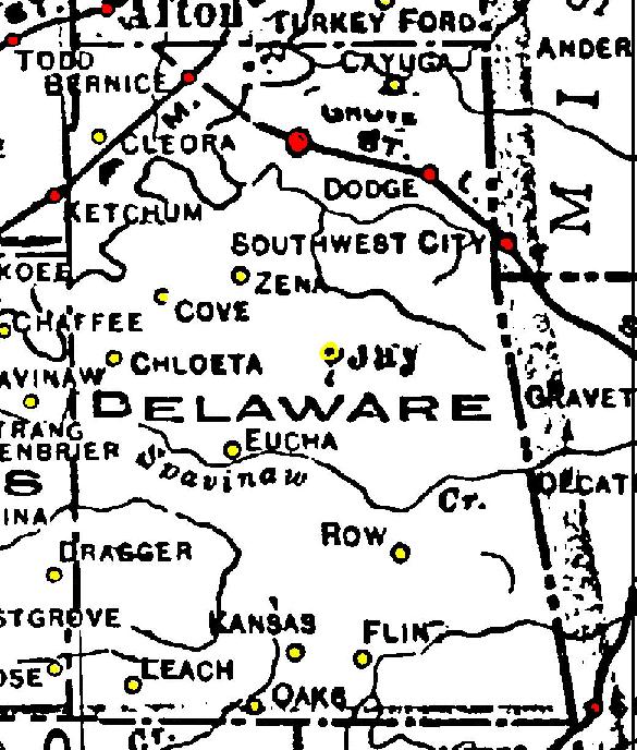
 Railroad Map Delaware Co. 1915, RR stations shown in
red, bypassed towns in yellow.
Railroad Map Delaware Co. 1915, RR stations shown in
red, bypassed towns in yellow.
1972 USGS
Maps of Oklahoma Counties
Cemetery
Location Maps By County
Cherokee
Nation Judicial Districts *
Index to Cities, Towns
and Communities
Index to
Post Offices
Index
to Townships
Indian
Territory 1817-1860
Oklahoma and Indian
Territory 1890
Oklahoma and
Indian Territory 1900
Present
Day Maps of Counties and Townships
Railroad
Maps of 1915
Township Grid
Maps
|