Bureau of Land Management
Oklahoma Land & Property - FamilySearch
Choctaw County
Genealogical Society
Land Resources
Maps
Choctaw County Maps
Maps - OKCHOCTA
1913 Choctaw County Map
1936 Choctaw County Plat Maps
Twp 5S Range 13E
Twp 5S Range 14E
Twp 5S Range 15E
Twp 5S Range 16E
Twp 5S Range 17E
Twp 5S Range 18E
Twp 5S Range 19E
Twp 5S Range 20E
Twp 6S Range 13E
Twp 6S Range 14E
Twp 6S Range 15E
Twp 6S Range 16E
Twp 6S Range 17E
Twp 6S Range 18E
Twp 6S Range 19E
Twp 6S Range 20E
Twp 7S Range 13E
Twp 7S Range 14E
Twp 7S Range 15E
Twp 7S Range 16E
Twp 7S Range 17E
Twp 7S Range 18E
Twp 7S Range 19E
Twp 7S Range 20E
Twp 8S Range 14E
Twp 8S Range 15E
Twp 8S Range 16E
Twp 8S Range 17E
Twp 8S Range 18E
Twp 8S Range 19E
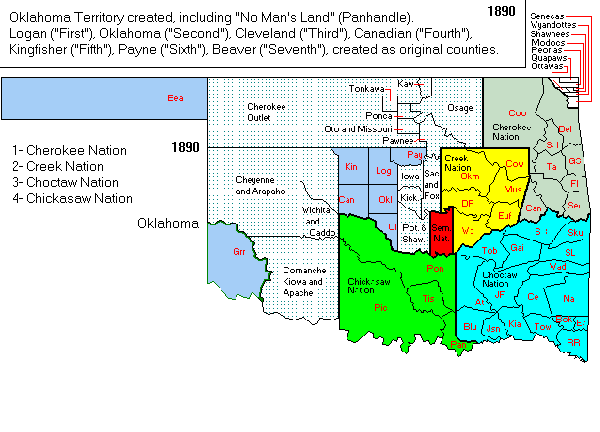
Oklahoma/Indian Territory Maps
(Use Ctrl +/- to adjust size, if needed)
1879 - Indian Reservations
1879 - Indian Territory
1888 - Indian Territory
1889 - Indian Territory
1892 - Oklahoma & Indian Territories
1900 - Map of Choctaw Nation
1900 - Oklahoma Territory
1901 - Oklahoma Territory
1903 - Choctaw Nation
1903 - Oklahoma Territory
1904 - Choctaw Nation
1905 - Oklahoma Map & Gazetter
1905 - State of Sequoyah
1910 - Choctaw Nation
1913 - U.S. Indian Reservations
Maps - ITGenWeb
Map of Oklahoma Counties / Regions
Map of Oklahoma / Indian Nations
Indian Territory County Map
Map Archives - OHS
Maps of Oklahoma
Map Collection - Tulsa City-County Library
Oklahoma Digital Maps Collection - OSU
Map Resources
Atlasas & Broad Map Collections
Davis Rumsey Historical Map Collection
American Memory Map Collection - LOC
Perry-Castaneda Library Map Collection - UT
Historic Map Works
Norman B. Leventhal Map Center
Ancestor Tracks
Alan M. Voorhees Collection
OldMapsOnline.org
National Library of Australia
Historical Map & Chart Collection
Historical Maps - UGA
Maps & Atlases - UGA
Maps & Atlases - WWW-VL: History: USA
Early Maps on the Web
Old-Maps (UK)
A Vision of Britain Through Time
MAGIC Historical Map Collections - UCONN
County Boundary Maps
The Gold Bug
State & County Boundary Maps - mapofus.org
Historical County Border Maps - Newberry Library
Historical County Boundary Maps - RandyMajors
2003 U.S. State & County Boundaries Map
Google & Map Overlays
Google Maps
Google Earth
Google Map Overlays - David Rumsey
Google Earth Overlays - David Rumsey
North Carolina Overlays
Scotland Map Overlays
Henry Hudson 400
Greater Philadelphia GeoHistory Network
Atlas of Historic New Mexico Maps
RetroMap - Historical Maps of Russia
State Maps
U.S. Digital Map Library - USGenWeb
State & County Maps - USGenWeb
Indian Land Cessions - USGenWeb
Cartographic Branch - NARA
Geography & Map Division - LOC
Florida Historical Map Collection
City Maps
Digitized Map Collection - LOC
Sanborn Maps, 1867-1970
Sanborn Maps Key
Other Map Resources
Maps on the Web
1914 County Maps by State
U.S. Genealogy Map Project
U.S. Genealogy Maps - Pinterest
Online Digital Map Collections by State
Maps & Geography - Cyndi's List
Google Map Tools
Historypin
WhatWasThere.com
Historvius
Tips for Using Maps for Genealogy
Using Maps in Genealogy
Six Tips for Mapping Your Family History
Maps in Family Research
Mapping your Ancestry with Google Maps
Using Historic Maps for Genealogy...
Quick Links:
Find us here:
CCGS
Research Library
Heritage Room Hugo Library
703 E. Jackson St.
Hugo, OK 74743
Research Library Hours
Mon, Tue, Thur: 9:00-7:00
Wed
& Fri: 9:00-6:00
Saturday: 9:00-2:00
Sunday: Closed
Donations:
CCGS is a non-profit organization supported solely on membership fees and donations.
We appreciate your support.