Chronicles of Oklahoma
Volume 10, No.
3
September, 1932
AN UNPUBLISHED REPORT BY CAPTAIN BONNEVILLE WITH
INTRODUCTION AND FOOTNOTES
By Grant Foreman
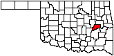
Page 326
Benjamin Louis Eulalie de Bonneville was born in France in 1793 the son
of a newspaper editor who was an intimate friend of General Lafayette. The
family won disfavor because of editorial statements denouncing Bonaparte
as a Cromwell of France and they were exiled to America. The son attended
the United States Military Academy and was graduated December 11, 1815. As
second lieutenant in the army he served in northeastern posts until 1819
and from that time to 1820 was engaged on the construction of a military
road through Mississippi and in the garrison at the Bay of St. Louis,
Mississippi. He was promoted to first lieutenant in the Eighth Infantry
July 9, 1820 and in the reorganization of the army became first lieutenant
in the Seventh Infantry, serving at Fort Smith from 1822 to 1824 and then
upon the abandonment of Fort Smith he accompanied his regiment to Fort
Gibson where he served until the next year. He then secured leave of
absence and went to New York to become secretary to General Lafayette on
his return to Europe. After this service he returned to Fort Gibson where
he served from 1826 to 1828.
Here Bonneville learned from returning travelers and traders much of
the romance of the unknown country to the west and as a result formed the
plan of heading an expedition to the Rocky Mountains. For this purpose he
secured a leave of absence and left Fort Gibson in 1830. He then secured
financial backing in New York and on July 29, 1830 secured another leave
from the War Department for two years. The following May with a company of
one hundred ten men including experienced hunters and trappers and twenty
ox and mule wagons loaded with supplies, ammunition and merchandise to
trade with the Indians, he started on his journey. He did not return
within the limits fixed by his leave and as a result his name was dropped
from the army rolls on May 31,
Page 327
1834. It was nearly fifteen months after that time that he reached
Independence, Missouri, from his western trip and continued to New York
and Washington where he brought pressure to bear for reinstatement in the
army. In this he was successful and an order was made restoring him in the
army and giving him the rank of captain of the Seventh infantry as of
October 4, 1825. He then returned to his regiment at Fort Gibson.
During his absence Captain Bonneville accumulated a large amount of
information much of which he preserved in written notes and descriptions
which he subsequently sold to Washington Irving and which became the body
of the book written by Irving, "The Adventures of Captain
Bonneville."
During Captain Bonneville's service at Fort Gibson and Fort Smith his
superior talents and training were requisitioned by his superiors for
important assignments. In 1836 Congress provided for the abandonment of
Fort Gibson and withdrawing the troops to the Arkansas line and building a
new post at Fort Smith, and for constructing a road along the western line
of Arkansas. Pursuant to this policy, Captain Bonneville and Colonel
Belknap were assigned to lay out a road from Fort Smith to Fort Towson
over a route different from that constructed by Captain Stuart in 1832.
The records of this work are preserved in the archives of the War
Department and copies have been deposited in the Oklahoma Historical
Society's collections.
In 1830 there was pending in Congress a bill providing for the removal
of the Indians from the eastern states to the west pursuant to the
recommendation of President Jackson. This bill was enacted into a law on
June 30, 1830. Directly after that the War Department exerted itself in
various directions to secure all possible information about the country to
which it was proposed to remove the Indians with the view to a more
intelligent understanding of the situation to meet the objections of the
Indians to removal; and to know more definitely what sections of the west
would provide homes for the Indians, the resources, soil, vegetation,
water supply, topography and other elements necessary to a proper
understanding of the subject. Information was solicited from the traders
and trappers in the western country and several military expeditions were
sent out from Fort Gibson to secure in-
Page 328
formation of this character and report to Washington.
In line with these efforts, instructions were given to Captain
Bonneville in September 1830 to examine and report on the features of the
country adjacent to the Canadian River from what at one time had been the
western boundary line of Arkansas westward to what was known as the Cross
Timbers which was assumed to be the limit of habitable land. The report
made by Captain Bonneville was recently discovered by the writer in the
archives in the Adjutant General's office in Washington together with the
map made by him, both of which are reproduced herewith. The report
reflects the opinion generally held in those days that the country in the
region examined and particularly the prairie country would not sustain
human life and Bonneville even went so far as to characterize it as a
barren waste. His judgment, in common with that of other authorities of
his time, is interesting as fixing the conceptions and standards of those
days by which white men measured the value of the new lands and countries
on the frontiers. His report follows:
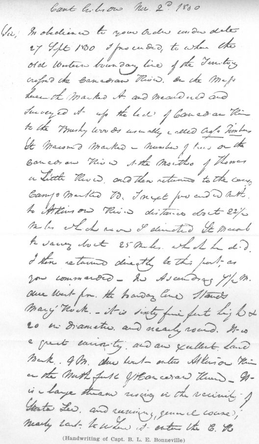
Cant Gibson Nov. 2nd, 1830.
Sir, In obedience to your Order under date 27 Sept. 1830 I
proceeded to where the old Western boundary line of the Territory
crossed the Canadian River, on the map herewith marked A, and meandered
and surveyed it up the bed of Canadian River to the Brushy Woods usually
called Crofs Timbers.1 Lt. Macomb marked a number of trees on
the Can-
1"The Cross Timbers vary in
width from five to thirty miles, and entirely cut off the communication
betwixt the interior prairies and those of the great plains. They may be
considered as the 'fringe' of the great prairies, being a continuous
brushy strip, composed of various kinds of undergrowth; such as
black-jack, post-oaks, and in some places hickory, elm, etc., intermixed
with a very dimunitive dwarf oak, called by the hunters, 'shin-oak.' Most
of the timber appears to be kept small by the continual inroads of the
'burning prairies;' for, being killed almost annually, it is constantly
replaced by scions of undergrowth; so that it becomes more and more dense
every reproduction. In some places, however, the oaks are of considerable
size, and able to withstand the conflagrations. The Underwood is so matted
in many places with grapevines, green-briars, etc., as to form almost
impenetrable 'roughs,' which serve as hiding-places for wild beasts, as
well as wild Indians; and would, in savage warfare, prove almost as
formidable as the hammocks of Florida." (Josiah Gregg, Commerce of the
Prairies).
Bonneville found the Cross Timbers in Seminole
county which was the limit of his western exploration. They extended about
north and south through middle Oklahoma, from the Cimarron to the Red
river and beyond.
Page 329
adian River at the Mouth of Thomas or Little River and then
returned to the Camp Marked B. I next proceeded north to Atkinson
River2 distance
about 22˝ miles which river I directed Lt. Macomb to survey about 25
miles which he did. I then returned directly to this post, as you
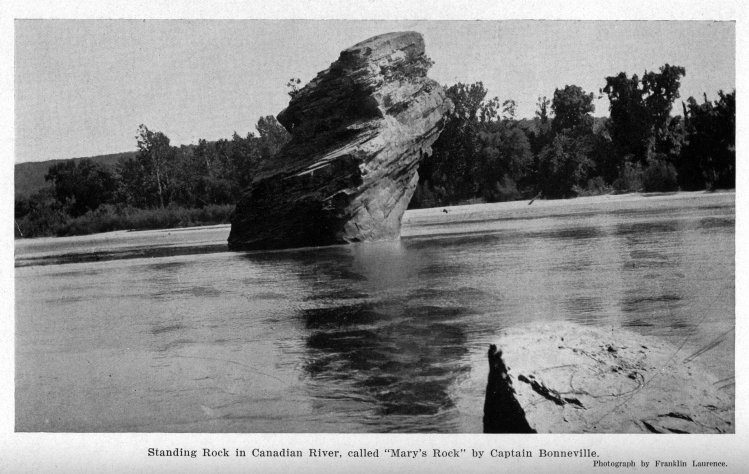
commanded. In Ascending 7˝ m. due West fr. the boundary line stands
Mary's Rock,3—it is sixty five feet high and 20 in
diameter and nearly round. It is a great curiosity and an excellent Land
Mark. 9 M. due West enters Atkinson River or the North fork of Canadian
River. It is a large stream rising in the vicinity of Santa Fee, and
running, general course, nearly East, to where it enters the C. R. It is
about 200 yds. wide at its Mouth and about the same where I
crofsed it above. I continued ascending the Canadian 12ľ miles
West from the same line came to the Mouth of Macomb River4 or the South
fork of Canadian River. It rises in the Mountains to the So. West and
running North and east to the Canadian. It is about 160 yards wide at
its Mouth. 51ľ M. due West from the line enters Thomas or Little River.
It is a beautiful stream entering the left bank of the C. R. about 100
yds. wide and has its source in the Grande Prairie west of the
Crofs Timbers. From its current and clearnefs I would
infer that it is mostly fed by Springs—The banks of the Canadian are low
from 3 to 6 feet high, sand hills frequently make to the River on both
banks. The bottoms are small, being generally sand beds covered with 5
or 6 inches of alluvial soil: there is but little timber in them. I saw
no place where I believed a settlement could be made to advantage—The
Prairies are rolling, of a light sandy soil having the common prairie
grafs—they are destitute of water and skirted with scrub
Page 330
and black Oak. The Circulars ifsued Head Quarters
Cincinnati Ohio 29 May 1826 directing an xamination and collecting of
Minerals and other curiosities, was also placed in my hands.—There are
no Minerals in the country—there was placed in my hands xtract of
general order H. Qs. Western Dept. Cincinnatti Ohio, 20 Nov. 1826.—I saw
no Indians, friends or enemies, though I heard of a party of persons
high up the Canadian felling cedar5 for market.—I have been absent about 20
days—yet I saw but little game, about 15 deer, 20 buffaloe,6 2 bears, and one
gang of Elk. The fact is the whole country is nothing but a barren
waste, having no cultivable land, no game no timber. My men were much
disabled disabled by sicknefs, having waded the Canadian upwards
of 300 times. Justice to Pvt Meigs—of G Compy. 7 Infy who was detailed
and accompanied me as my doctor compels me to say that his skilful
practice was xtremely succefsful tho he had mostly to contend
with violent fever, dysentaries and spasms.—I hope the Comdg Officer
will his xertions to have pvt Meigs compensated for his services as
surgeon to my xploring and Surveying xpedition.
I have the Honor to be Sir
Yours Respectfully
B.L.E.
BONNEVILLE,
Capt. 7th Infantry.
5In 1928 George Nidiver and
Alex Sinclair and some other men from Missouri "went up the Canadian fork
of the Arkansas and began the building of a large raft of cedar logs,
which we intended to float down to New Orleans to sell. We were engaged
with a few men we hired, nearly a year in making the raft. When everything
was ready and we were about to start down the river the Cherokees to whom
that section had been ceded attempted to seize our raft, but taking
advantage of a freshet we sailed down in the night beyond their reach and
escaped them. This availed us but little however, for at the mouth of the
fork the raft ran aground, was broken up, and we abandoned it" (Journal
of George Nidiver, Bancroft Library, University of California; Grant
Foreman, Indians and Pioneers, 179. In those early days there was
an enormous quantity of fine cedar timber on the Canadian and Arkansas
rivers.
|