
|
Caddo County, OK
OKGenWeb |
 |
|
|
Caddo County, OK
OKGenWeb |
|
By Evert Cook*
Boone township, in the southwest central pari of Oklahoma, is joined on the east by Abilene township in which the town of Apache is located, on the west by Cache township, which is the most southwesterly town ship in Caddo County, and on the south by Comanche County.
It is twenty-five (25) miles south-southwest of Anadarko, Oklahoma and the same distance north-northwest of Lawton, Oklahoma. Incidently, it has been right here as long as this planet has been in existence. There are fossils called gastrolites embedded in the limestone of the Slick Hills that are estimated to be four hundred million years old. Life beyond that in Boone township is unknown.
Human life, however, extends beyond the ten thousand year mark. Arrowheads and other artifacts have been found that date back to, and before, ten thousand years ago.
Artifacts at Indian campsites are found at most springs, which show that people have lived here along these clear creeks for a long time. Cache Creek is so named because of some early explorers that buried their money along its banks. Cache, in French, means to bury something and is pronounced "cash." East Cache Creek, the largest one of these, heads a few miles west and flows southeast across Boone township, cutting off a few sections in the northeast corner.
Da-Ha Creek runs west to east and divides the community at about the center. Da-Ha Creek was named after an old Indian that lived in a teepee about a mile and one-half northeast of where the Boone School now is, in the years 1 870's and 1880's.
He was of the Kiowa-Apache tribe, but according to Blossom Houzous, he had married into their tribe, which was Ft. Sill Apache.
In later years some white people of the community confused the
name Da-Ha with another Indian who pronounced his name almost the same
but spelled it To-Who (pronounced Ta-ha'). Da-Ha was an Apache chief
who signed a peace treaty with the government.
Jim Myers verified this fact to the writer a few years before he died. Mission Creek, which runs from west to east in the south part of the community, is so called because of the Indian mission located on its course. One other creek that runs out of the hills and crosses Hi-way 19 west of Boone is still called Cook Creek by a few of the old timers. In the horse and buggy days the writer, with his parents, lived at this crossing. The cool, clear water of Cook Creek was welcomed by many a tired horse and weary traveler, more so than a gas station today.
The limestone hills that occupy the southwest part of the township are supposed to be one of the oldest formations in the world. Geologists say they were formed in layers laying horizontal and in later years the Wichita Mountains pushed up through them and caused them to be like they are now.
The rest of the township is fairly level and has been covered with grass for ages past. One old settler told the writer when he first came here that the grass along Cache Creek was as tall as a man's head when he was sitting on a horse.
We do not know for sure what tribes of Indians lived here prior to about 1800. We know that the Kiowas, Comanches, and Apaches came here about that time from the northern and northwestern part of the United States, and they have been here ever since.
The first white man to set foot on the Boone community was probably an Indian trader prior to 1834, for we know that it was in that year the first dragoon of soldiers was in this vicinity.
It is possible and we know there were some white captives at times among the Indians. The first white family to come here to make their home was Dr. Carithers and his wife and daughter, who founded the Cache Creek Mission in 1889, but the history of the mission is a story in itself. That, I hope someone else writes.
Other early day white visitors to this locality were the Indian agents, soldiers, and army personnel located at Fort Cobb, which was established in 1859 to fight Indians and protect emigrants that were moving westward.
When Ft. Sill was established in 1869, there immediately sprang up a trail and wagon road across our community between the two points. It came south from Ft. Cobb, crossed Cache Creek one-fourth mile east of Hatchetville by the high creek bluff where the oil field now is located. It came on south to a point from Boone School one mile east, one-half mile north, and one-fourth mile east to what they called a half-way house, being half way between Ft. Cobb and Ft. Sill. It was a dwelling house with two rooms facing the south with a shed roof on the north. It was built for Old Chief Da-Ha, a Kiowa-Apache, who signed one of the peace treaties with the Government. Not the famous "Medicine Lodge Treaty," but one at Ft. Gibson in 1877. Old Chief Da-Ha wouldn't live in the house, but lived in a tent down on the creek.
It being the only house between Ft. Cobb and Ft. Sill, the soldiers kept horse feed and other supplies in it and camped there almost continually for several years. It was called "The Half Way House."
The reason Dr. Carithers built the Mission where he did was because he thought someday there would be a railroad built from Ft. Cobb to Ft. Sill, as they were the two most western outposts at that time.
One other trail that should be mentioned is the one known as the Anadarko Trail.
The man that represented the U. S. Government and took care of the Indians was known as an Indian Agent. He was located at this time at Ft. Sill, but the Indians had been at war with the soldiers and it created a problem so the agency was moved to what is now Anadarko. It was then called the Wichita Agency, and immediately another trail came into existence. It served mostly the Kiowa Indians living in the Wichita Mountains. Its existence extended from 1878, when the agency was moved to Anadarko, until one or two years after this community was opened to settlement. It entered Boone township at about the southwest corner and followed down Da-Ha Creek through what we used to call "The Gap." Then as it crossed Boone township it went on the ridge that divides Cache Creek and Da-Ha.
Adolf and Neils Christensen, now living in Apache, lived beside this old trail. They said there were hundreds of wagons, both Indians and whites, trudging along at a snail's pace day after day. Where the wagon road made a bend following the ridge, the horseback trail cut across, first on one side then the other. The ruts of the wagon wheels cut deep in the sod and can still be seen in the pastures where it crossed this community. It crossed Cache Creek near Hatchetville, also the natural bridge near the Apache Y on Hi-way 9 north of Apache, then on to Anadarko. It was discontinued when the country was fenced in.
Animal life in the Boone community has always played an important part. Archaeologists tell us that in ages past this country was wet and marshy and fern grew as tall as trees. Giant lizard-like monsters lived, waded, fought and died here. Some of their bones have been found in the creek banks. The writer (Mr. Cook) himself, found the leg bone of agiant elephant in the creek bank on Da-Ha Creek a few years ago.
Historians tells us that mountain lions and bears used to roam out on this prairie country, and they kept the buffalo here to a minimum until the white traders and explorers with guns in the 1820's shot some, then the rest retreated into the mountains.
Statistics show the buffaloes doubled and tripled in number from the year 1830 to 1870. In the year 1870 all of what is now Boone township was dotted with buffaloes. Then the slaughter began. From other states, hundreds of men poured into this part of the country, including Boone, with horses, wagons, and high powered rifles. Within ten years, the buffalo herds had been destroyed; the carcasses left to rot in the grass. The hides had been hauled by wagon and team to the nearest railroad, which was southern Kansas, and sold for $3 each. A few years later other men less adventurous, came in by wagon and team and picked up buffalo bones and sold them for fertilizer.
This community has been populated with horses for about 350 years. The Spaniards left some horses in Old Mexico soon after Columbus discovered America. They increased under ideal grazing conditions until the Indians of the western half of the United States were mounted on horseback. When the first white explorers came west, these Spanish horses were small in size. The largest ones weighing about 800 pounds. A few were trim built ponies, others were raw boned with long mane and foretop and a tail, long and heavy, that touched the ground. Some had crooked legs and a Roman nose. They were all colors. When the white people came to the west with better horses, the young brave that could steal a good horse from the white men was looked upon with pride.
The white people had larger horses; some Percherons weighing 1800 pounds. In the 1930 s when the tractors took over the farm work, Hycel Smith of the Boone community, owned some of the world's finest work or draft horses. Since the days of the tractor and automobile the horse population has decreased until there is not a work horse left in the community. In recent years the quarter horse has been improved and a few people keep them, mostly for pleasure.
Cattle in this part of the country have been the main source o, income for many people. The first cattle brought here in large numbers were driven here by Jim Myers in 1872. At that time the only settlements in southwestern Oklahoma were Ft. Sill and Ft. Cobb. All the land and grass belonged to the Kiowa, Comanche, and Apache Indians. The buffalo had been killed off and the U. S. Government was having to take care of the Indians. So the Government, with the permission of the Indians, leased the grass of southwestern Oklahoma to cattlemen from Texas for a few cents per acre per year. Jim Myers leased a tract of land extending approximately from Ring Top Mountain, due east almost to Fletcher, then north along a line just on the west side of Cyril and Cement. From there it turned west and missed Ft. Cobb about six miles to the south. In fact it took in, generally speaking, the land drained by Mission Creek, Da-Ha Creek and Cache Creek from where it enters Comanche County to where it heads in Kiowa County to the north and west. This took in several townships including all of Boone Township.
Jim Myers operated this ranch from 1872 until the coming of the white p3ople in 1901. The first wire fence was built by Jim Myers on the ridge that divides Chandler and Mission Creeks. Some of the old rock posts can still be seen. This fence was built in approximately a half circle and took in all the head waters of Mission and Cook Creeks. In later years, Jim Myers built a fence from the ranch located one-half mile south of Boone several miles north to Cache Creek so his cattle could run on open range west of the fence.
When the first settlers came in, Jim Myers fenced some of their fields so his cattle could still run at large over open country. The only houses here at the coming of white settlement were at the Myers ranch, and two houses that had been built by the U. S. Government for two Apache Chiefs, the Half Way House, previously mentioned, and one for an Indian named White Man. It was located from Boone one mile south, three-fourths west and about 200 yards north in a field. The remains of an old cellar and rocks from the fireplace can still be seen.
Before the country was opened to settlement, the Government had surveyed the country and partly buried a rock at each section corner one mile apart. Families who drew farms considered these corner stones as being official boundaries for their farms. However, some dishonest settlers have been known to have moved the stone a few feet to obtain more land.
The only early day post office was Onasco, located on the SE 1/4 of section 6 in the northwest corner of the district.
In 1901, Louise Stinger built a store 12' by 20', with a few groceries in one end and got a post office established in the other. She submitted several names for her post office to the U. S. Government but there was already a post office by the names she submitted, so the Government sent the name Onasco and no one knows its origin.
Louise Stinger had operated the store and post office for about one year when George Dolan built a much bigger and better store across the road. She sold her stock of groceries to Dolan and the post office was moved to Dolan's store. George Dolan was appointed postmaster. George Dolan was also the school teacher at Prairie Center school located near by.
Sorn Christensen got the job of carrying the mail on what they called a Star Route from Apache to Onasco, a distance of about ten miles. Clyde Snodgrass was the substitute carrier until Christensen's eldest son, Martin, was big enough to carry the mail.
The post office at Onasco was done away with when the rural route was established in 1910, out of Apache. The store part was closed down in 1925 and the building was accidentally burned in 1928.
Soon after the white people were settled in their new homes, three small schools were built in each corner of the township. People in the southeast corner sent their children to the Indian school, already established at Cache Creek Mission. The southwest school was located from Boone one mile west, one and one-half miles south and was called Sulphur Spring School, because of a sulphur spring near by. In the northwest corner was Prairie Center, so named because of the open prairie on which it was built. It was located one mile north, one mile west, and then one-half mile north of the present Boone School. In the northeast part of the school district was the Beall School, named after two families by that name. Spelled BEALL but pronounced Bell, and located from Boone School, which is the center of the township, one mile east, two miles north and then one mile east.
These little school houses were often called "cracker box schools," because of their size and shape. They had an attendance of from 30 to 50 pupils, ranging in age from 5 to 21 and sometimes older with one teacher and grades from the 1st to 8th. The students usually walked from one to three miles to school, sometimes through rain and snow. My own brothers and sisters were caught in a blizzard on the way home from Sulphur Spring School. Night came on and my mother was worried. So my father went out in the blowing snow on horseback to find the kids. They had stopped in at a neighbor's house two miles from home. My dad visited until midnight while my mother walked the floor.
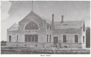
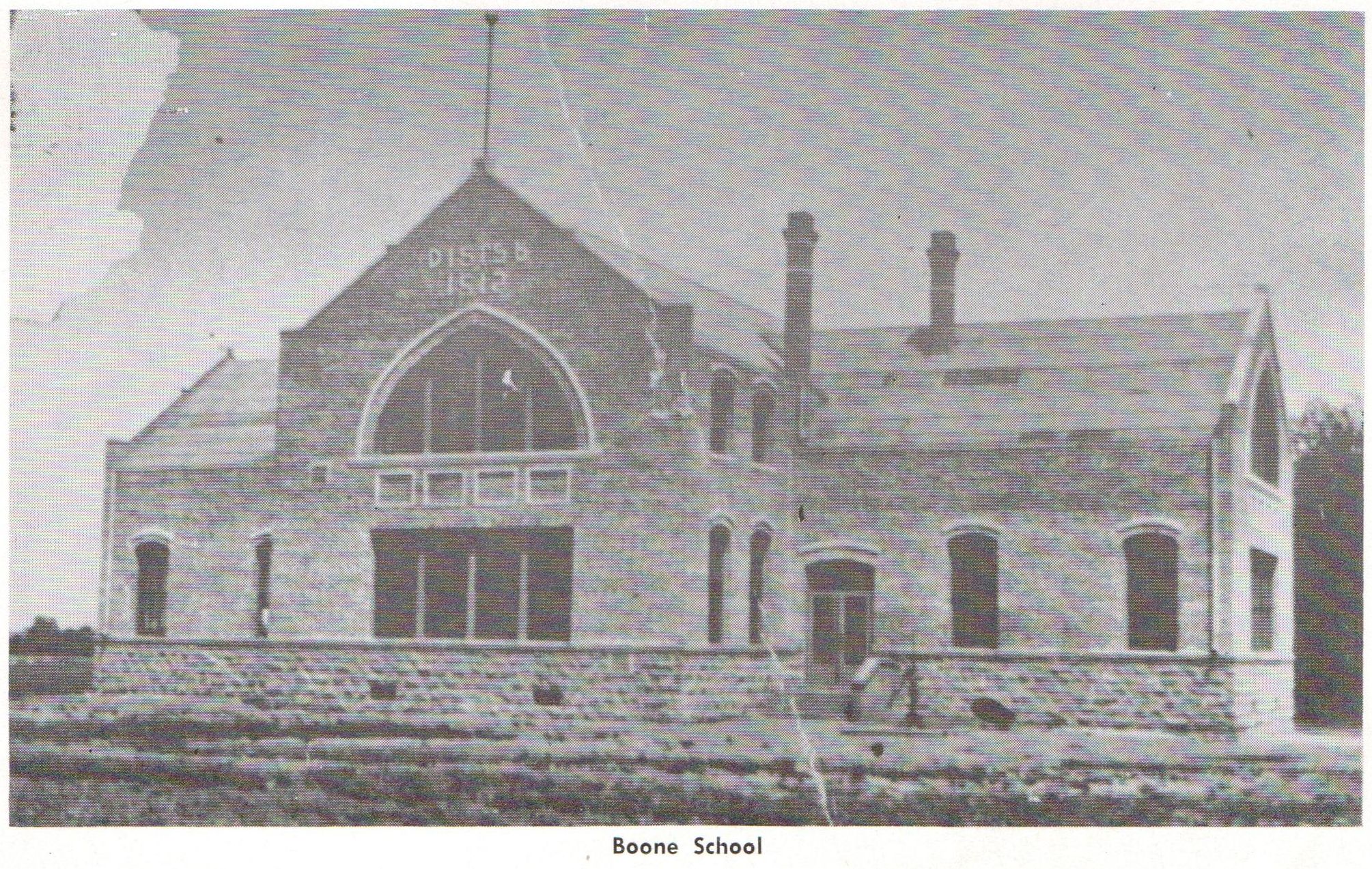
In 1912 the four small districts consolidated and built one of the finest school houses in southwestern Oklahoma at that time, but not without a struggle. There were die hard conservatives in those days that wanted to stay with small schools. They contended that we are all farmers and an eighth grade education was all a farmer needed.
The new school was built in the center of the township, which
had been named at the first meeting of the newly elected board of
county commissioners at Anadarko in August, 1901. It was called Boone
township after Albert Boone, a grandson of Daniel Boone, Kentucky
frontiersman. Albert Boone worked out of the Indian Agency at Anadarko
and was agent for the Kiowa-Apache Indians that had their main camp in
the bend of Da-Ha Creek were Boone School now stands. These were his
Indians and his township, so consequently they named this Boone
township, after Albert Boone.
When the new school was built, it was called Boone School because it was in Boone township and what a fine school it was! The rocks for the foundation and for about eight feet up on the walls were dug out of the hills two miles west. The old quarry can still be seen on the north side of where Hiway 9 cuts through the hill and near the spring on the Boy Scout Camp.
The new school was the talk of the community with its classrooms, halls, winding stairs, auditorium and stage. (The writer of this bit of community history attended the first school program held there.)
The school had an attendance of over 200 the first few years. The primary teacher had about 60 beginners, and some of those little Indians couldn't talk English. Two teachers for the rest of the grades and one teacher taught the whole high school.
The school district bought four covered wagons and let them out to the lowest bidder to someone in the community to drive a school wagon route. The farmer furnished his own horses and hauled the pupils from the four corners of the district to school. My father drove one a few years for $40 a month. Some people now days talk about the good old days, but I can say from experience the younger generation isn't missing anything except some frozen ears and fingers and toes.
One morning a team of mules ran away with the wagon I was in. One wagon full of kids was nearly washed away crossing a creek that was up—no bridge! Another family of children were thrown out of the buggy and cut and bruised and bones broken when the horse ran away. I could go on and on with similar incidents.
In the fall of 1914, the professor and some of the big boys came across the school yard carrying some long poles. Someone said they were going to put up basketball goals; but, no one had ever seen it played.
In 1923, the county agent, Mr. I. E. Gnuter, from Anadarko, came to Boone and organized the first 4-H Club. One of the highlights of that year was when he came and took us over the community in his car to look at farm projects.
Three of the old school wagons were disbanded in 1924 and the last one in 1925. The boys my age felt very important and grown up when the whole school loaded on to go home and some of us boys would walk out in front and crank those old Model T Ford trucks. When it rained and you came to a mud hole—there were many—the kids would all pile out and the driver would make a run at it in low gear wide open. If he didn't quite make it, some of the kids would push. Driving a school bus with single tires in deep ruts in the mud, always reminded me of riding a bucking horse or shooting the rapids in a swift river in a canoe.
But as time went on and roads were improved and with later model buses the students now days don't know by experience what I am writing about.
Considering everything, I think the Boone community with its good people, its diversity of crops, livestock, oil wells, good roads and homes, and a good school and churches is one of the top communities in the state of Oklahoma in which to live. I am sure if the school system of Apache would check its records, they would find that they have had more A students, more valedictorians, salutatorians, athletes, etc. from Boone than any other surrounding community.
* Evert Cook has lived nearly all his life in the Boone community of south Caddo County, Oklahoma. He is a widower and is the Camp Ranger for the Camp George Thomas Boy Scout Camp, west of Apache, Oklahoma.
Boone township, Caddo County is T 5 N, R 12 W, I.M., Oklahoma. Ed.
![]() SEARCH
SEARCH
E
Mail
Mel Owings - coordinator
This page last updated Sunday, July 26, 2026
Copyright © 2001 - 2026 Mel Owings