History of Alfalfa County
Alfalfa County was formed in 1907 from
Woods County, Oklahoma originally called M County. The county is
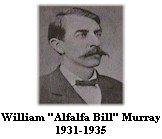
named after William H. "Alfalfa Bill" Murray.
|
|
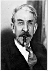
William
Henry Davis "Alfalfa Bill" Murray,
Probably Oklahoma's most colorful
political figure, William Murray was born November 21,1869, in
Collinsville, Texas. At twenty years of age he graduated from
College Hill Institute in Springtown, Texas. For the next six
years he held various jobs, including day laborer, teacher,
editor of a Dallas farm magazine, and of a Corsicana daily
newspaper. Admitted to the Bar in 1895, he practiced at Fort
Worth before moving to Tishomingo, Indian Territory, in 1898.
There he became legal advisor to the Governor of the Chickasaw
Nation. He was President of the Oklahoma Constitutional
Convention in 1906; Speaker of the House of Representatives,
1907-1908; Member of the Sixty-third and Sixty-fourth United
States Congresses; and Governor of the State from January 12,
1931, to January 15, 1935. At his urging, the Legislature
created the Oklahoma Tax Commission. His ranching interests
spread from Oklahoma to Bolivia, South America, where he
established a colony. He wrote articles and books, mostly
dealing with constitutional rights. He died October 15,
1956
The William H. Murray Collection at Carl
Albert Center. |
 |
At the
constitutional convention before statehood in 1907 Woods County was
divided becoming Alfalfa
County, Major County and Woods County.
Major Andrew
Drumm helped form the Cherokee Livestock
Association. The Association leased land from the Indians to graze
cattle on. This land was located in what is now Alfalfa County.
Alfalfa county is located in
land that was part of The Cherokee Outlet/Cherkee Strip
. The land was opened for
settlement with the land run Sept. 16th 1893.
More History
on The Cherokee Strip/Outlet Debate
ITGENWEB-The Cherokee
Strip/Outlet
- The Cheokee Strip-Ponca City
News
- http://www.usgennet.org/usa/ok/state/outlet/strip.html
Towns in Alfalfa
County still listed on the
2005 Map of Oklahoma are:
-
Aline,
-
Amorita,
-
Burlington,
-
Byron,
-
Carmen,
-
Cherokee,
-
Driftwood,
-
Goltry,
-
Helena,
-
Jet,
-
Ingersol,
-
Lambert,
-
McWillie
-
Yewed.
|
|

|
|
|
Page Last Updated: 5.17.2013 |
|
|
|
Alfalfa County Coordinator
Marty Myers
martymyers@sbcglobal.net
©1996 to Present - All Right
Reserved
OKGenWeb Copyright Notice:
The creator copyrights ALL files
on this site. The files may be linked to but may not be
reproduced on another site without specific permission from
the Haskell County OKGenWeb Coordinator and their creator.
Although public information is not in and of itself
copyrightable, the format in which they are presented, the
notes and comments, etc. are. It is, however, permissible to
print or save the files to a personal computer for personal
use ONLY.
USGenWeb Copyright Policy
It is the policy of The USGenWeb Project
to obtain permission from the creator of the code, graphics,
and backgrounds before using them on our pages unless they
have been placed in the public domain.
|
| |
|