
Maps
'n' More
Created
By
Sharon McAllister

|
|
Maps
'n' More |
|
|
|
||
|
|
|
||
|
|
|
|
|
|
|
|
|
|
|
|
|
|
|
|
|
|||
| Back to Garvin County Township Maps | Back to Garvin County Cemetery Lists |
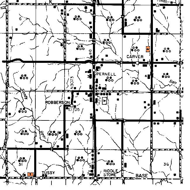
Garvin County - T1N-R3W
Directions
provided by Brenda
Choate. See the Garvin
Co. Map for more details.
Dripping Springs - Not Shown. From Highway 76 turn back west at the Tussy sign. Drive down a couple of miles. You will pass a place where you can turn back north where oil field tanks are located. Go past this to the next place you can turn back north. Go through the gate and stay on the main path for about 2 miles or so. You will come to the cemetery behind a stand of trees on the east side of this oil field road. The gate just off the Tussy road has been kept locked in the past but for now I believe the land leaser says he no longer keeps it locked.
Little Flock - Off Highway 74 about 5 miles or so south of Elmore City turn back west at the cross roads. Drive down 3 to 5 miles. You will see a small church back off the road on the north side of the road. The cemetery is behind it. (This should be in the northwest quadrant of T1N-R3W, but doesn't match the cemetery shown in Section 11 and is not on GNIS.)
Robberson - NE4 of Section 19. Terry Johnson took me to this cemetery. We went up Hwy 76 south to the road that intersects the Hwy just as the Pernell school and turned right/west. We went straight and where the paved road curved back south we took the dirt road straight instead of taking the curve. We drove straight on to a red gate, then straight on to a wire gate, and just inside that second gate we turned south and drove for about 1/4 mile, stopped and crawled under a fence and walked about 150 yards into the pasture. The cemetery was located in a thicket of trees. It is not being taken care of. It has no fence or sign. Terry said the Robberson Townsite was located right by the cemetery but there is no sign of it now. He indicated that the gates are kept locked as the cemetery is on leased land where cattle are kept. There may well be more graves here than listed but not that you could readily see. See Topozone Map.
Tussy - Section 31. From Highway 76 turn back west at the Tussy sign. Drive down 5 miles or so. You will pass the post office which is on the south side of the road and then come to the cemetery which is on the north side of the road. Can't miss this one.
Unknown - Section 11. Not shown on USGS map.
![]()
|
Page last updated
on
Tuesday, July 21, 2026
This site maintained by
Mel Owings
![]()