|
|
Cherokee
County |
|
|
Home |Archives
| Cemeteries |
Lookups | Obits | Queries | Resources | Surnames | Additional
Links |
||


Cemeteries
Oklahoma
Cemeteries
OK
CEMETERIES GEN WEB PROJECT
The VA's
Nationwide Gravesite Locator
Tombstone Transcription Project for
Cherokee County
Oklahoma Cemetery
Listings for Cherokee County
Oklahoma
Gravestone Project for Cherokee County
Cherokee
County at Interment.Net
Cemeteries in
County Archives
Vietnam War casualties
from Oklahoma
City
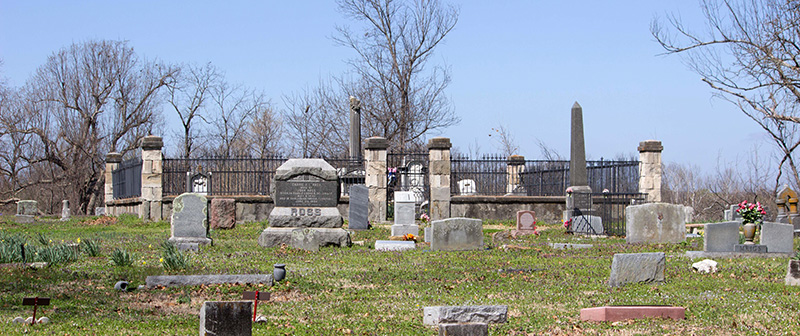
of Tahlequah Cemetery
Cemetery entrance photos
Directions to find the Cemeteries And Links
If you know of any that might have been missed, or if
you have some information that you would like added,
PLEASE contact
me so that I might get them listed.
Alberty, Buffington, Harlan, Parris
(Colored) and Taylor Cemeteries were moved to make Fort Gibson
Lake and are now know as J J Cemetery
(Information was contributed by: Kay
Hubbard Thompson) (More information below)
ADAM HENDRICKS
CEMETERY (From Pioneer Papers)
One mile East & ¼ mile south of Shady Grove
School. (NE 17 17N 21E).
Agent Cemetery, Contributed by: Kay
Hubbard Thompson 7/31/2002
Tahlequah, Oklahoma
(At find a
grave) (At OKCemeteries.net)
Take Highway 82-A to Moodys & go .05 mile
past Moodys Store& the cemetery is on the left
(More on Agent Cemetery
)
ANDERSON
LOWERY CEMETERY (From
Pioneer Papers)
Mr. Anderson Lowrey is a son of Chief George Lowrey. There is no marker at his grave, but Mrs. R.W.
Walker was with me and showed me his grave. (Mrs. R.W. Walker of Tahlequah,
Oklahoma) This is a nice family cemetery, well kept
and fenced.
Ballew Cemetery Contributed by: Brenda
Ballew Griffin 7/06/2002
This cemetery was located in the SW1/4 NE1/4 of Sec
10, T14N, R22E, it was fenced and well-kept. Initially, the cemetery was used
as
the burial ground for the Ballew family, but gradually members of the community
started using it also. In or around 1948 Tenkiller
Lake was being
built. The location of the cemetery is now under
water. Reinternment was to be made in a cemetery approximately 1.7 direct
miles north-northeast of Old Cookson, Oklahoma,
in the southeast corner of Sec 2, T14N,R23E.
Which is known as the Cookson-Proctor Cemetery
today.
COOKSON-PROCTOR CEMETERY
Contributed by: Brenda S. Franklin
More on the Cookson-Proctor Cemetery
by Jennifer Sparks
in 2006
BARBER CEMETERY
Contributed by: Kathe Determan Dec2005
(At find a grave)
(At OKCemeteries.net)
In Tahlequah turn north on the road that says Tenkiller
Lake or Tenkiller Dam. Go over the Illinois River and
turn left and go east on North 100 towards Stillwell. At the bottom of a hill
on the east side of the road there is a road that says Welling Road and across
North 100 is a bar named Kooter Brown's. Directly before
you reach this bar on the west side there is a road named S. 585 with a sign
that reads Barber Cemetery. The cemetery is behind this bar.
Blue Springs Cemetery, Contributed by: Kay
Hubbard Thompson 8/03/2002
Gideon, Oklahoma (At OKCemeteries.net)
Starting at the end of the Bertha Parker Bypass and Grand Avenue go
north of Tahlequah 6.4 miles on 82 highway, turn left off of 82 highway onto a
dirt road, there is a sign there that says Blue Springs Baptist Church, go .03
of a mile turn right and go .02 of a mile and turn right. The cemetery is behind
the Gideon Fire Station and beside the Blue Springs Baptist Church. (More on Blue Springs Cemetery. (Partial)
Contributed by: Charlie Crocker
on 10/7/2002
Barnes Family Cemetery
(at find a grave) - Moody
Batt Cemetery (Oaks)
(at find a grave)
Beehunter
Cemetery (Robbins) (at find a grave) -Welling
Bigfeather
Cemetery (at find a grave)
Bill Batt Cemetery (Rocky Ford)
(at find a grave) Photos
Blair Cemetery(Cookson)
(at find a grave)
Blue Springs Cemetery
(at find a grave) -Gideon- Photos
Bolin Cemetery
(at find a grave)
Briggs Cemetery
(at find a grave)
BOUDINOT CEMETERY Contributed by: Kay
Blanchett 02/24/2004
Tahlequah,
Oklahoma (at find a
grave)
caney Cemetery (Submitted by JBornho664@aol.com
9/23/2000)
Tahlequah, Oklahoma (More on Caney Submitted by: Cheri
Stokes 11/5/2002) (at find a
grave)
Starting at the traffic signal at the intersection of Bertha Parker
Bypass and East Downing; go east on Downing (outside of the city limits it is
highway 51/62) 2.6 miles and turn right onto Welling Road (there is a convience store where you make the turn) stay on Welling
Road for 6.2 miles and there will be a paved road that turns to the left (Tailholt Road), turn left, continue down that road to where
the road will make a Y, take the left arm of the Y, go 3 miles and you will see
the old Tailholt store on the right, the road makes a
Y again, at this point the pavement ends and the road becomes dirt, take the
left arm of the Y again and go 2.1 miles, you will see the cemetery; there are
two sections to the cemetery with a road in between them.
Contributed by: Kay Hubbard Thompson
5/12/2002
Cedar Tree Cemetery Contributed by: Kay
Hubbard Thompson 6/01/2003 (at
find a grave)
From the intersection of Bertha Parker Bypass and Downing Street
(highway 51/62) go east on Downing 4.7miles, the cemetery is on the right side
of the road on the grounds of the Cherokee Baptist Campground.
Chambers Cemetery
(at find a grave)
Choska
Bottom Cemetery (at find a grave) -Moodys
Church of Jesus Christ Cemetery
(at find a grave)
Cherokee Native Cultural Society
Asylum Cemetery Contributed by: Kay
Hubbard Thompson 9/12/2002
Tahlequah, Oklahoma
No directions given
Cherokee Native Cultural
Society Asylum Cemetery Marker
Contributed by: Kay Hubbard Thompson
5/13/2003
The directions for the Cherokee Asylum Marker is
directly north across the highway from Sequoyah High School on 62 highway
Clay Cemetery
(at find a grave) -Welling-
Cobb Family Cemetery (Formerly listed as
Briggs Free Holiness Cemetery Updated 3/15/2003 at request of
submitters.) (at find a grave)
BRIGGS FREE HOLINESS CHURCH CEMETERY
Briggs, Oklahoma
This is a rather small cemetery. It can be found on the grounds of the Briggs
Free Holiness Church, located in Briggs, OK. Traveling west
on Highway 62 through the town of Briggs, one can see the cemetery on the left hand side of the road. The cemetery is directly next to
a small
white church, which can be plainly viewed from the highway. Note: if you reach
the Briggs School on 62 West, then you have gone too far and passed
the cemetery.
Contributed by: Shannon Seyler,
Randal Seyler, and Julius Seyler
8/25/2001
Cochran Cemetery
(at find a grave) -Hulbert-
Cockrum
Cemetery (at find a grave)
Cookson Family Ranch
(at find a grave)
Cookson-Proctor Cemetery
(at find a grave)
Crescent Valley Cemetery
(at find a grave)
Crittendon
Cemetery (at find a grave) -Gabriel-
Crittenden Cemetery Contributed by: Kay
Hubbard Thompson 5/13/2003 (at find a grave)
Tahlequah, Oklahoma
From the intersection of Highway 51 west and the 51/82 spur go west on Highway
51 .03 miles. Turn right on Bryant Road (the Pepsi Plant is on the left) and go
.06 miles to 750 Road (there is a sign that say City Limits) turn left on 750
Road and go 1.3 miles the cemetery is on the left.
Crail Family Cemetery
Relocated
Yonkers
* Established in
1880
David Carter Family
(at find a grave)
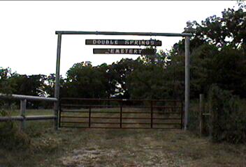
Double Springs Cemetery
Tahlequah, Oklahoma (at find a grave)
Head north of Tahlequah on Hwy 82 to Jones Road (Joes Red Barn) Turn West. Go
until you come to a T in the road (approx 3 miles,
half way changes to dirt road) turn South. Go about 1/4 mile,
Double Springs church on West side with a house next door (to the South) the
Cemetery is through the gate just past the house on the right. The gate is not locked.
Be sure to close the gate, there are cows in that little field. Cemetery in the
back. Contributed by: Zanna Guinn 9/6/2005
Duck Cemetery (Manard
Bayou) (at find a grave)
Eureka Cemetery Contributed by: Kay Hubbard Thompson
5/13/2003
From the intersection of Muskogee Avenue and Bertha Parker Bypass (Wal-mart) in Tahlequah; go west on the Bypass for 1.6
miles, turn left onto 4th Street (Mud Valley Road) and go 3.8 miles; turn left
onto dirt road and go 1.5 miles; the cemetery is on the right. (at find a grave)
Eureka- Coos Thompson Road, Hulbert 74441,* Established in 1800
Eureka Springs Cemetery
(at find a grave)
Flint Ridge Cemetery Contributed by: Kay
Hubbard Thompson 6/26/2002 (at find a grave)
More on Flint Ridge Cemetery
Gourd Cemetery Contributed by: Kay
Hubbard Thompson 8/22/2002 (at find a grave)
Tahlequah, Oklahoma
Go north of Tahlequah on 82 highway 5.4 miles (from the end of the
Bertha Parker Bypass). Turn right and go 2.1 miles, when you come to the
"y" in the road stay to the right. Stay on the blacktop for all of the 2.1 miles. The sign is beside the road on
the left. The cemetery is off the road up the little lane that runs
in front of the sign. (More on Gourd Cemetery)
Grandview Cemetery Contributed by: Kay
Hubbard Thompson 9/06/2002 (at find a grave)
Tahlequah, Oklahoma
Go north on highway 82 to Jones Road (Joe's Redbarn),
turn left on Jones Road and go 1.4 miles to the four way stop. Turn left on
Jarvis Road (dirt road) at the four way stop, go 1.4
miles to the Grandview School and turn right on the pavement at the west end of
the school building and the cemetery is on the left.
(More on Grandview Cemetery)
Gray CEMETERY (at Find a
Grave) Cedar Crest
(360413N-0951139W) It is about ¼ mile within the border of Cherokee County from
Mayes County.
Greenleaf Cemetery Contributed by: Kay
Hubbard Thompson 8/03/2002 (at find a grave)
Tahlequah, Oklahoma (at OKCemeteries.net)
1.5 miles from Sequoyah School on highway 62 south
Gulager
Family Cemetery (more) (more) (more) (all at find a
grave)
GREECE CEMETERY (From
Pioneer Papers)
About a ½ mile south & 100 yards west of Double Springs School, NE SE10 17N
21E.
Hare Cemetery
(at find a grave)
Hendricks Cemetery Contributed by: Kay Hubbard Thompson 8/03/2002 (at
find a grave)
Tahlequah, Oklahoma (At OKCemeteries.net)
Right next to the Greenleaf Cemetery. 1.5 miles on south highway 62 from the
Sequoyah School
Headstone index for some Tombstone
pictures at the Cemetery
Hendricks-Linder
Burial Ground
Hicks Cemetery Contributed by: Kay Hubbard Thompson 5/12/2003 (at
find a grave)
From Bertha Parker Bypass and Downing Street intersection in Tahlequah go east
on Downing (51/62 highway outside city limits) 4.4 miles; turn left on Lutherhoma Road (B & J Salvage is on the right) go 3.2
miles (.03 mile after you pass Todd Access Area-first dirt road to the right)
turn right go .03 miles and turn left on Rich Mac Lane, go .03 miles and
cemetery is on the left in the middle of the cow pasture.
Hinson
Cemetery (at find a grave)
Holland
Cemetery
Contributed by: Terrill White
1/29/2003 (at
find a grave)
Tahlequah, Oklahoma
Holland Cemetery between Woodall (Cherokee County, OK) and Ft. Gibson, OK. It
is also known as the Crescent Valley or Coodey
Cemetery and is located Northeast of Crescent Valley Baptist Church. This is
where most of my White's are buried.
Houston
Cemetery (more)
(at find a grave)
HULBERT CEMETERY
The Hulbert Cemetery is the same as the Odd Fellows Cemetery. To get there from
Tahlequah, you would go east on Hwy 51 straight through Hulbert about one mile.
You will then see kind of fork in the road---the Hwy will kind of curve to the
right and a little road will go off to the left and there
is a memorial of some sorts in the middle. (See below) Turn left onto
the road. The cemetery is a short distance on the right.
(Submitted by Terrill White
4/6/2004)
(More on
Hulbert Cemetery from Pioneer Papers)
Some added information by:Jaqueline (Jackie) Spears
"The
memorial at the fork in the road off of Hwy. is a
memorial to Viet Nam Veterans. I only point this out because a young man
I knew growing up named Flud died in Viet Nam and I
think his grandfather who was close to my family was instrumental in getting
the memorial erected."
IOOF Cemetery (Partial listing-) Provided by Jackie Spears (at
find a grave)
Tahlequah, Oklahoma (At OKCemeteris.net)
From Rider Lane and 51 highway go .05 miles and turn right onto Hulbert Landing
Rd.
Go 1.4 miles, the cemetery is on the right. Contributed by: Kay Hubbard Thompson 7/31/2002
JJ CEMETERY is located approximately one mile North
on Sunset Valley Road west of Hulbert. It is very easy to miss as it is
so grown up. Terrill White took pictures of all of
the graves that he could see but was almost positive that there are MANY, MANY
more graves in this cemetery because he kept stumbling in deep impressions and
there were many field stones in the cemetery. Many of the headstones were
homemade and the newest grave was from 2004. (Some Tombstone
Photos - Provided by Terrill
White)
(at
find a grave)
JOHNSON CEMETERY
(From Pioneer Papers)
Tahlequah, Oklahoma
Located ¾ mile north & ¾ mile east of Hulbert (NE NW 24 17N 20E). This
cemetery is on a knoll adjoining the highway on the south side. It as a wire
fence enclosure about 100 feet square. There are about 35 graves with sandstone
markers but no inscriptions on any of them. All buried in this Cemetery are
Cherokee Indians except one white baby. The above information given by Madison
CAREY a full blood Cherokee.
(More on Johnson
Cemetery, Contributed by: Kay
Hubbard Thompson 8/22/2002) (at
find a grave) (more
at find a grave)
Johnson
Family Cemetery (north of Moodys) (at find a
grave)
(More on Johnson
Family Cemetery Contributed by Jim Johnson 3/23/2002)
Jones Cemetery (at find a grave)
Keener
Cemetery (Tahlequah) (at find a grave) -Lost City-
Keener
Cemetery (Tahlequah) (at find a grave)
Keener Baptist Cemetery Contributed by: Kay Hubbard Thompson 7/31/2002
Hulbert, Oklahoma
Take Lost City Rd out of Hulbert 4 miles to the 4-way stop and turn left, go
.09 miles
and church is on the right, the cemetery is behind the church.
Keener Cemetery
Contributed by: William Jack
Whitener 11/23/2003 and updated on Mar2011
Levi Cookson Cemetery Contributed
by: Brenda Ballew Griffin 7/16/2002 (at
find a grave)
Tahlequah, Oklahoma
Located between Pettit and Qualls
Contributed by: Kay Hubbard Thompson
8/22/2002
More on the Levi-Cookson Cemetery
by Jennifer Sparks in 2006
LINDER CEMETERY
Contributed by: Tammy Thornton
Turney 1/14/2002 (at
find a grave)
Cemetery is located close to Hulbert.
(More on Linder
Cemetery)
Linder
(Manard Bayou) (at find a grave)
Linder
(Manard) (at find a grave)
Long
Springs Cemetery (at find a grave) -Briggs-
Looney Price
Cemetery, (From Pioneer Papers)
Located two and 1/2 miles southwest of Sequoyah Indian training school on 62 highway.
Lost
City Cemetery, Contributed by: Kay Hubbard Thompson 7/31/2002 (at
find a grave)
Hulbert, Oklahoma
Take Lost City Road out of Hulbert, go 3.7
miles the cemetery is on the left next to Lost City School.
(More on Lost
City Cemetery)
Lower Ray Cemetery (at find a grave) -Hulbert- Photos
Lowrey Cemetery (at find a grave)
Manus Cemetery, Contributed by: Kay Hubbard Thompson 7/31/2002 (at
find a grave)
Tahlequah, Oklahoma
From the intersection of Bertha Parker Bypass and Downing Street in Tahlequah,
go east on Downing Street (51/62 Highway) 2.5 miles to
Welling Road turnoff. Turn right (south) on Welling Road and go 1.7 miles; turn
left (east) on gravel road and go 1.4 miles;
turn right (south) and go to the end of the road. You're there.
(More on Manus
Cemetery)
MANUS
CEMETERY on line
(Some more on Manus
Cemetery) Sent in by: Ernie Briggs
:"I
mow and maintain Manus Cemetery. I donate my time and equipment, but I
pay to have a person help me. If anyone would like to donate, mail
donations to: Manus Cemetery, 17628 S. Rocky Top Lane, Tahlequah, OK
74464-2023"
Martin Reese Cemetery Contributed
by: Terrill White 1/26/2003 (at
find a grave)
Tahlequah, Oklahoma
It is located on Manard Road between Woodall and Fort
Gibson, OK. The small sign is located right on the road and is easily missed.
The cemetery itself is setting way off the road in the woods and as can be seen
is not maintained.
McKee
Family Cemetery (at find a grave)
Miller Cemetery, Contributed by: Patricia
Jones Jan2001 (at
find a grave)
Tahlequah, Oklahoma
More on Miller
Cemetery by Sue Ellen (Dobson) Berry
More on Miller
Cemetery by Patricia E. Jones
From the intersection of Highways 62 & 82 south of Tahlequah go west on 62
2.2 miles turn right onto Stick Ross Mountain Road, go 1.4 miles turn left on
South 490 Road (Miller Cemetery Road), go 1.0 miles and take the main road to
the left, at this point the pavement ends and the road is dirt (straight ahead
is a dead end) and go .06 miles, the cemetery is on the left.
Contributed by: Kay Hubbard Thompson
5/13/2003
Molly Field Cemetery,
Contributed by: Kay Hubbard Thompson
5/13/2003 (at
find a grave)
Tahlequah, Oklahoma
More on Molly
Field by Zelma Richardson
From Bertha Parker Bypass and Downing Street intersection in Tahlequah go east
on Downing Street ( it will become 51/62 highway outside city limits) 1.8 miles
to the intersection of Highway 10 and 51/62 Highway, turn left on Highway 10
and go 10.6 miles, the cemetery is on the left.
Moodys Cemetery,Contributed
by: Kay Hubbard Thompson 8/03/2002 (at
find a grave) (more
at find a grave)
Moodys, Oklahoma
Go north of Tahlequah on 82 highway, take the 82-A (Moody's) exit (about 3.3
miles from the end of Bertha Parker Bypass); go 3.3 miles on 82-A turn right
onto 82-B and go .03 miles the cemetery is on the left.
(More on Moodys Cemetery Part 1
and Part
2)
Mt. Zion Cemetery Contributed by: Kay Hubbard Thompson 5/13/2003 (at
find a grave)
Tahlequah, Oklahoma
Some Photos
contributed by Jan Inman on 10Jun2009
From the Highway 51 Spur and Highway 51 West in Tahlequah go west on 51 highway
for 3.2 miles; the cemetery is on the right at the
intersection of McCrary Road and 51 Highway.
Neugin Cemetery (at find a grave) -Hulbert-
New Home (at find a grave) -Tahlequah-
New Home Cemetery, Contributed by: Kay Hubbard Thompson 7/31/2002 (at
find a grave)
Peggs, Oklahoma (Some Information
by Dianna Miller Souza)
1st left turn after 82 Mini Mart in Peggs, go 1.3
miles, cemetery is on the left.
(Complete
listing On Line by Lloyd
Ray Timmons, Sr.) Some
Cemetery History
NEW HOPE
CEMETERY (From Pioneer Papers)
One mile East & one mile north of Hulbert (NE SE13
17N 20E). Formerly known as the CAREY Cemetery & was first used as an
Indian Cemetery in 1860. Many of the graves are not marked & inscriptions
on some of the markers are in Cherokee.
New Hope Cemetery, Contributed by: Kay Hubbard Thompson 7/31/2002 (at
find a grave)
Hulbert, Oklahoma
Take Lost City Rd. out of Hulbert, go .09 mile and turn right on Shady Grove
School Rd., go 1.3 miles and turn right at the
New Hope Cemetery sign and go .01 mile, the cemetery is on the right.
North
Ray Cemetery (at find a grave) -Hulbert-
Oaks Cemetery (at find a grave) -Scraper-
Odd
Fellows Cemetery (at find a grave) -Hulbert-
Park
Hill Cemetery, 5/12/2003
Cherokee Co. Oklahoma (at find a grave)
From the Highway 62 West and Highway 82 South Junction outside of Tahlequah
turn left onto Highway 82 going towards Keys. Go 1.1 mile and turn left, go .02
miles and the cemetery is on the left side of the road.
PARRIS CEMETERY
Contributed by: Kay Hubbard Thompson
1/8/2003 (at
find a grave)
The Parris Cemetery is located just north of the Parris Church and School,
which is on the old site of the Cherokee Keetoowah Council House which stood on
the high bluff overlooking Fourteen Mile Creek. (From the Parris Cemetery on
Pioneer Papers)
(More on Parris
Cemetery)
Peggs Cemetery, Contributed by: Lisa Richardson
Peggs, Oklahoma (at
find a grave)
1st right after the 82 Mini Mart, go .04 mile the cemetery is on the right.
Contributed by: Kay Hubbard Thompson
7/31/2002
PETTIT CEMETERY Contributed by:
Jennifer Spark in 2006
Pettit
Cemetery (at find a grave)
Philipps
Cemetery (at find a grave) - Paradise Hill-
Phillips
Cemetery (at find a grave) - Qualls-
Post
Cemetery (at find a grave)
Price
Cemetery (at find a grave) -Tahlequah-
Pumpkin Center/Hollow Cemetery, Contributed by: Kay Hubbard Thompson 5/13/2003 (at
find a grave)
Cherokee Co. Oklahoma
From Bertha Parker Bypass and Downing Street intersection in Tahlequah, go east
on Downing (it will become 51/62 highway outside city limits) 4.4 miles; turn
left on Camp Lutherhoma Road (B&J Salvage is on
the right) go 3.7 miles to where the road T's, take the road to the right and
go 2.5 miles, the cemetery is on the right.
Ray Cemetery, Contributed
by: Kay Hubbard Thompson 7/31/2002 (at
find a grave)
Tahlequah, Oklahoma
From the 14 Mile Creek bridge on highway 51 West go 6.0 miles to the Sequoyah
State Park entrance, turn left into Sequoyah State Park and go 1.2 miles to the
Seminole Area entrance and turn right, go .02 miles and the cemetery is on the
right beside the Ray Church.
Added information by: Jaqueline (Jackie) Spears
"The
directions to the Ray Cemetery seem to identify only
the part of the cemetery right next to the church. There is another part
about .01 mile further on, same side of the highway. It was not well kept
when I visited there this past spring but hopefully my cousin has seen to it
that it is better now. It is surrounded by a picket fence. Several
members of the Cochran family (including my great great
grandfather) are buried there."
Rigsby
Family Cemetery (at find a grave)
Rose/Westmoreland
Cemetery (at find a grave)
Ross
(Allen), Tahlequah, (at find a grave)
Ross Cemetery, Contributed by: Kay Hubbard Thompson 7/31/2002 (at
find a grave)
Tahlequah, Oklahoma
Cemetery is located on Bliss Avenue across from W.W. Hastings Hospital
(More
on Bliss Ave Ross
Cemetery, Tahlequah By Kay
Hubbard Thompson)
Ross Cemeteries, Contributed
by: Terrill White 1/29/2003
F.Y.I. There are 2 Ross Cemeteries in Cherokee County.
One is located on Bliss Avenue across from the W.W. Hastings Hospital. The
second and probably most sought after is in Park Hill, OK. Ross Cemetery that
is located on Bliss Avenue is a predominantly black cemetery. These Ross' are
related to Stick Ross which was a freedman (freed slave). When Stick was freed
he was allotted land just Southwest of Tahlequah on what is now known as Stick
Ross Mountain.
Park Hill Ross Cemetery,
Contributed
by: Terrill
White
1/29/2003 (at
find a grave)
Park Hill, Oklahoma (Also at Internment net)
No directions given but I feel it is at the Murrell House location. It is one mile East and then one half mile south of the Murrell
Home. This cemetery holds the remains of many prominent Cherokee including
Chief John Ross. The cemetery is fairly well
maintained as it is still in use and has been added to the National Registry of
Historic Places.
(More on Ross
Cemetery, Lewis Ross Plot, Park Hill by Terrill White)
Sanders Cemetery (at find a grave) -Tailholt-
Sellers Mission Cemetery, (at
find a grave)
This cemetery is on the Qualls Road between S. Burnt Cabin Road and W.
Stone Chapel Road off highway 82 going to Tenkiller.
Cannot give the exact mileage marker at this time. The Mission has a
Church as well.
Seminole Cemetery (at find a grave)
Shirley Cemetery, Contributed
by: Kay Hubbard Thompson 6/01/2003
(at
find a grave)
Cherokee Co. Oklahoma
From the intersection of Bertha Parker Bypass and Downing Street in Tahlequah,
go east on Downing (highway 51/62) go 7.4 miles, the road makes a Y take the
right fork of the Y toward Stillwell; go .09 mile from that point to the first
dirt road that turns right, take the right and go .06 mile and you will see the
sign on the left side of the road. The cemetery is up behind the Shirley Free
Holiness Church.
South
Ray
Cemetery, Contributed by: Kay Hubbard Thompson 6/11/2003
Cherokee Co. Oklahoma
From the 14 Mile Creek bridge on highway 51 west of Hulbert go 2 miles, turn
right on Clear Creek Road and go 1.4 miles, turn right and go 1 mile. The
cemetery is on the left. This cemetery also includes graves from the Baldridge
Cemetery and several other small cemeteries in the Ray community. These graves
were moved to make the Fort Gibson Reservoir in 1951.
Steeley Cemetery, Contributed
by: Kay Hubbard Thompson 5/13/2003
Tahlequah, Oklahoma
From the intersection of Highways 62 & 82 South of Tahlequah take 62
highway and go 2.2 miles to the intersection of Highway 62 and Stick Rosss Mountain Road, turn right onto Stick Ross Mountain
Road and go 1.4 miles, turn left onto South 490 Road (Miller Cemetery Road) and
go 1.0 miles the road will turn to dirt stay on the main road and go .03 miles
the cemetery is on the right.
Stonerose Cemetery (So. of Tahlequah) (at find a grave)
Swimmer
Cemetery(Gideon) (at find a grave)
Swimmer Baptist Cemetery,
Contributed by: Kay Hubbard Thompson
7/31/2002
Hulbert, Oklahoma
Take Lost City Rd. out of Hulbert, go 4 miles to the 4-way stop, turn right and
follow road about 3 miles, as you start
around a big curve you will see the sign that says Swimmer Baptist Church, the
cemetery is behind the church.
Tahlequah Cemetery, Contributed by: Patricia Jones Feb2001 (at
find a grave)
Tahlequah, Oklahoma
(More on Tahlequah
Cemetery by Patricia Jones)
The cemetery is on West Fox Street in Tahlequah Contributed by: Kay Hubbard Thompson 7/31/2002
Cemetery
Listing (Very slow loading) by City
of Tahlequah
Talala
Cemetery Contributed
by: Susan Large
10/11/2002
(Partial listing)
Teresita
Cemetery
Contributed by: Kay Hubbard Thompson
4/15/2004 (at
find a grave)
Go north of Tahlequah on 82 to 82 & 82-A intersection, turn right on
82-A to Moodys, after you pass Moodys store go north about 6.1 miles you will cross a
metal one lane bridge; go .04 of mile and turn left by the old Teresita store
building, the old store building is white and there is a mobile home at the
south end of it; go about .01 (the top of the hill) up the dirt road, turn
left down a narrow lane and go .03 miles as you cross the cattle guard you will
see the sign and you are in the cemetery, most of the graves are on
the left side of the road as you go into the cemetery, the sign is on the
right.
Thompson Cemetery, Contributed
by: Kay Hubbard Thompson 2/28/2003 (at
find a grave)
Tahlequah, Oklahoma
It doesn't sound like it is in Cherokee County but you go out of Cherokee
County into Delaware County then you come back into Cherokee County by the time
you reach the cemetery. Here goes: From Mollyfield
Cemetery on Highway 10 north of Tahlequah go 7 miles to Chewy Road, there is a
big sign for the Illinois River Ranch on the right side of the road, turn right
on Chewy Road and go 2.2 miles, turn right into the Illinois River Ranch
property and go .08 of a mile, the road t's, take the right turn and go 2.7
miles; the gate is on the right side of the road, the cemetery is down in the
field.
Turkey Lee Cemetery (at find a grave)
Ward Family Cemetery (Hulbert)
Weeley Cemetery Contributed by: Kay Hubbard Thompson 5/04/2003 (at
find a grave)
Starting at the traffic signal at the intersection of Bertha Parker Bypass and
East Downing Street go east on Downing. At the city limits Downing Street
becomes highway 51/62, go 2.6 miles from the intersection and turn right on
Welling Road (there is a convinence store where you
turn), go just under 8 miles on Welling Road, you will pass the Etta Baptist
Church and the road will curve to the left and a wide dirt road will go to the
right, when you are starting into the curve you will see a green sign that says
Weeley Cemetery where the dirt road goes off the
curve, there is a narrow driveway down to the cemetery it is not really visible
from the road unless you look real hard.
White Oak cemetery, Contributed by: Kay Hubbard Thompson 8/22/2002 (at
find a grave)
Tahlequah, Oklahoma
No directions given
Some information on the White Oak
Cemetery by Jennifer Sparks
in 2006
William H. Hendricks, Jr./Anna Eliza Linder Hendri
Worcester Mission Cemetery
Contributed by: Terrill White
2/2/2003 (at
find a grave)
Directly across from the Park Hill Cemetery, Park Hill, Oklahoma
Worchester
Cemetery (at find a grave) -Tahlequah-
Worster Cemetery (at find a grave)
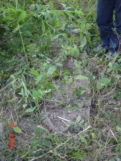
FORGOTTEN
BURYING GROUND (From Pioneer Papers)
In the extreme southern section of the Park Hill locality, Oklahoma, not
far distant from the Illinois River, there is on the bench of a high wooded
hill an early day and forgotten place of burial.
A Forgotten and unknown Burial Ground (Source: Jerri Barton )
To get to the site: From Hwy 62 and 82 south of Tahlequah, go 100 ft south. Take Murrell Home Road 3 1/2 miles.
Turn south at 410 Rd (posted as King Road) for 1 1/3 miles, going to the left
when the road forks. You will find yourself at the cattleguard of Sundown
Ranch. Follow this road until it again forks,,
do NOT go towards the large house to the west, but cross the cattle guard
straight ahead and follow a "pasture road" that is well used by the
owners of the 13 "river-front" properties. From the first
cattle guard, it is a little over 1/2 mile down this road to where the gravesite
is. To the south of that road and 100' up the pasture, you will see 2 walnut trees growing
close together. This burial site is right beneath those trees but
other in the winter time, you can see no stones at all. And even in the
winter you have to almost be on top of them to see
them. To us, it looks like there are probably 3-4 grave there (based on indentations in
the earth) but if the "vandalism" is true, that might not be the
case. There is the "large massive"
stone of Elizabeth Delano that is there and another standing stone that states
"E D". which might be a footstone.
20 years ago you could see the flying dove and the willow tree, but could not
read the stone since it was broken, but you can't read the stone at all anymore (This stone was vandalized and previous
owner's decedents report knowing of people trying to rob this grave.
Plus, it is not fenced and cattle do run it).
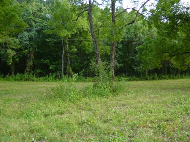
Another Unknown Burial Area on Stick Ross Mountain
There is no name for the one on Stick Ross Mountain --off Mud Valley Road turn
south onto Stick Ross--go to top of hill--on right side is a rock house (old
Garner place) across the road on the left side proceed about three to five
hundred feet is an area overgrown. A person will have to get permission
to search this area. This cemetery, which is not very large, about 10 graves, was
among the trees, it had a small wall surrounding the graves only about 12 to 16
inches high. Linda Peck
Trail
of Tears Cherokee Indian Removal enroute to (at
find a grave)
Thanks for stopping by.
This page
last modified: Wednesday, January 17,
2018
Join the "You Might Be From Tahlequah If..."
Facebook group for ongoing discussions on the history of Tahlequah
& Cherokee County This page is maintained for the OKGenWeb A Sincere Thanks To All Contributors !!!!!! USGenWeb NOTICE: In keeping
with our policy of providing free Information on the Internet, data may be
used by non-commercial entities, as long as this message remains on all
copied material. These electronic pages may NOT be reproduced in any format
for profit or for presentation by other persons or organizations. Files may
be printed or copied for Personal use only. Persons or organizations desiring
to use this material for purposes other than stated above must obtain the
written consent of the file contributor.


God Bless America
