|

|
Timeline in
Maps
|
The phrase "Indian Territory" usually brings to mind the
southeastern half of the present state of Oklahoma, one of the Twin
Territories that were admitted to the Union as a single state in 1907.
Indian Territory actually existed under a
formal Territorial
Government for only a very brief time, but the phrase has also been
used to describe many different regions down through the years as
westward expansion changed the face of the Nation.
Historically, the older term "Indian
Country" is actually a
more useful description. If these maps appear crude, it's
because they have been re-created from notes and sketches for a Term
Project when I was in college many years BPC [Before Personal
Computers]. I have made no attempt to track every encroachment
and every land cession -- only to depict general boundaries as they
existed at different times, with respect to present state lines.
More specific migration paths can be found in exploring the appropriate
First Nation
Histories and the individual land cessions that are covered on many
state pages -- but I believe this is enough to show how
Tribes and Nations from such varied parts of the country ended up in
what is now Oklahoma.

Click on thumbnail map to see a larger
version.
|
|
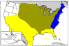
In the early 1700s,
Britain controlled the
eastern coast (shown in blue), while France held the Mississippi Valley
(shown
in olive green) and Spain had Florida and
the Great Southwest (shown in yellow). Only the British displaced
the natives with
their settlements, so in this period everything that isn't blue
was
generally considered to be "Indian Country". |
|
|
At the Treaty of
Paris
in 1763, France ceded her land east of
the Mississippi to England. King George III issued the
Indian Proclamation Line that ran
along the crest of the Appalachian Mountains, creating the first
official Indian
Country. It extended from the Appalachians to the Mississippi and
south to
the Spanish lands. |
|

|
The British then
proceeded to negotiate
treaties and acquire lands for future settlements. By 1768
the Ft. Stanwix Treaty opened all lands south of the Ohio to the mouth
of the
Tennessee River. |
|
|
After
the American Revolution, the new Treaty of Paris of 1783 officially revoked the Indian
Proclamation Line, recognizing both intervening land cessions and the
settlements that had already encroached across the Appalachians into
the Ohio Valley. Natural barriers, like the Ohio River, were
again used as boundaries between white settlements and Indian Country. |
|
|
After
the Louisiana Purchase in 1803, there was
a movement to make the Mississippi River a natural barrier, with Indian
Country to the west and everything east to be opened to
settlement. This map shows the logic of the proposed
division. |
|
|
A
period of rapid westward expansion followed and the line between white
settlements and Indian Country was in a state of rapid flux. By 1810 land cessions had extended west of the
Mississippi. Although they were not organized as a territory, by
policy the western lands were reserved for resettlement of eastern
tribes. |
|
|
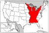
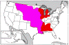
The
Indian Trade and Intercourse Act of 1834
created an Indian Territory (shown in red)
that included all United States territory west of the Mississippi,
except the states of Louisiana and Missouri and the Territory of
Arkansas. It also included some areas east of the Mississippi in
present-day Florida, Michigan, Wisconsin and Minnesota to which Indian
Title had not been extinguished (these small isolates are not shown
here). |
|
|
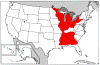
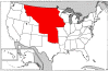
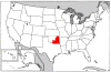
By 1854,
Indian Territory covered only the area
west of Arkansas and Missouri, from the Red River to the Missouri
River, and west to the 100th Meridian. The Cherokee, Chickasaw,
Choctaw, Creek, and Seminole occupied all of what is now Oklahoma,
except the panhandle. Others had been relocated to what would
later become Kansas and Nebraska. |
|
|
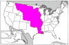
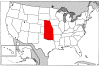
After
the Civil War, the Five Nations were forced to cede their western lands
and tribes from the Great Plains were relocated there. By 1876, with the admission of Kansas and Nebraska
to the Union, Indian Territory had shrunk to what is now the state of
Oklahoma, excluding the panhandle. |
|
|
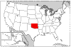
With
the passage of the General Allotment Act and the creation of Oklahoma
Territory, by 1889 Indian Territory had
shrunk to its final form: the Five Nations (Cherokee, Chickasaw,
Choctaw, Creek and Seminole) and the Quapaw Tract. |

Status: This section is essentially complete, if you can
think of anything that could be added, let me know. THANKS!
|